

Лёд и Снег, 2023, T. 63, № 3, стр. 410-425
First 10Be dates of Late Holocene moraines of the Kashkatash and Irik glaciers, Northern Caucasus
O. N. Solomina 1, V. Jomelli 3, I. S. Bushueva 1, 2, *
1 Institute of Geography Russian Academy of Sciences
Moscow, Russia
2 Aix-Marseille University
Marseille, France
3 HSE University
Moscow, Russia
* E-mail: irinasbushueva@gmail.com
Поступила в редакцию 16.06.2023
После доработки 21.06.2023
Принята к публикации 21.06.2023
- EDN: PLXOVJ
- DOI: 10.31857/S2076673423030110
Аннотация
We present 11 10Be ages of the moraines of the Irik and Kashkatash glaciers that allowed identifying and dating several Late Holocene glacier advances for the first time, including a prominent advance exceeding the Little Ice Age (LIA) maximum that occurred at 1.6–1.7 ka at еру Irik Glacier. The advance is dated by the three very close 10Be ages of a moraine (1.57 ± 0.23 ka, 1.63 ± 0.23, and 1.68 ± 0.24 ka) located in the vicinity of the moraines of the Little Ice Age (LIA) maximum advance. The advance that occurred at 1.6–1.7 ka might be a possible analogue of the “Historical” stage described earlier in the Caucasus in literature basing at geomorphic evidence, speculations, and analogues with other mountain regions, but not dated. Another possibility is a potential correlation of this advance with the Late Antique Little Ice Age cooling in 536 to ~660 CE. The age of Irik Glacier advance is close to the humid period identified in the Garabashi (Baksan, Elbrus valley) lake sediments at 1500–1700 years BP. The magnitude of the identified glacier advances over the past two millennia was similar. Between the advance of 1.6–1.7 ka and the position of the glacier in 2022 CE the elevation of the Irik Glacier front increased by 520 m from 2490 to 3010 m asl. Four 10Be dates (0.7 + 0.11, 0.72 + 0.11, 0.77 + 0.11 and 0.82 + 0.18 ka) of the lateral moraine of the Kashkatash Glacier constrain the advance of the first stage of the LIA. The advance of the 13th century is also dated by 10Be at the Donguz-Orun and Chalaati glaciers located at the Northern and Southern slopes of the Caucasus, respectively. The corresponding cooling in ca 1250–1400 CE is identified in the sedimentary paleoclimatic proxies of Lake Karakel (Teberda valley). A later advance at the Kashkatash Glacier is constrained by only one 10Be date (0.53 ± 0.13 ka) and needs further confirmation. Till deposited between the 1490s and 1640s at the Greater Azau Glacier is close to the date of this advance of the Kashkatash Glacier. A cooling at that time is recorded in the proxies of Karakel Lake sediments (1500–1630 CE). Three other 10Be dates of two earlier advances at 0.25 + 0.04 ka and between 0.14 + 0.03 and 0.16 ± 0.02 ka at Kashkatash Glacier are indirectly supported by tree-ring, lake sediment, 14C, and historical data. Further research and new data is necessary to increase the credibility and accuracy of the dates of glacier advances of the Late Holocene in the Northern Caucasus.
INTRODUCTION
The timing of Holocene glacier variations in the Caucasus preceding the past 100–150 years is poorly documented. Tree-rings and lichenometry were used for the dating of earlier advances (see review in Solomina et al., 2016), but these dates of moraines are minimum limiting only and therefore they are often uncertain. Tree-ring dates in the Caucasus hardly cover the period of the last 300–350 years (Solomina et al., 2021). Moreover, most glaciers in the Caucasus do not reach the upper tree line and even these approximate age estimates of moraines are not applicable for them. Lichenometry was used as an alternative, but these dates are not very reliable especially for the surfaces older than five hundred years or so. Solomina et al. (2022) recently reported the radiocarbon dates of paleosols buried in the lateral moraines of the Greater Azau Glacier and documented this way four periods of glacier advances that occurred in the past 3 ka, but the chronology of glacier variations might be incomplete and the position of moraines corresponding to the respective advances is not known.
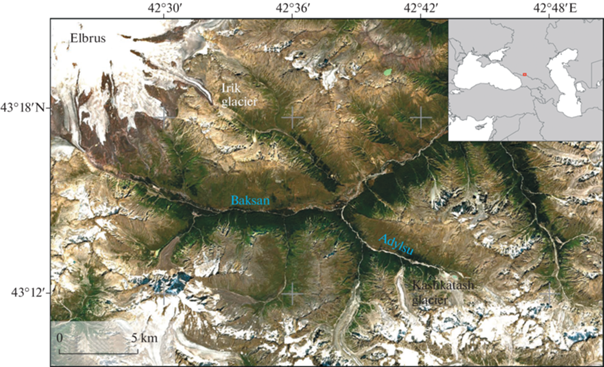
The Cosmic Ray Expose (CRE) method provides new insight into moraine dating. It was largely applied globally in order to date the glacial landforms (e.g. Balco, 2011, 2020). By now only sporadic single CRE dates of moraines were reported in the Caucasus (Bushueva et al., 2015, Tielidze et al., 2020). We will discuss these dates below in the context of new findings. In this paper, we provide 11 new CRE dates of moraines of the two glaciers Irik (43.31N; 42.53E) and Kashkatash (43.20N; 42.68E) (Fig. 1) in the Near Elbrus area in the Northern Caucasus and compare them with our previous estimates of the age of moraines derived from tree rings and lichenometry. We also assess the scale of glacier retreat since several Late Holocene glacier maxima.
We visited the moraines of the glaciers and sampled for tree-ring, lichenometry and CRE several times in 2004, 2008, 2009, 2013 and 2022. The CRE dates are reported here for the first time, some tree-ring and lichenometric records were partly published previously (e.g. Solomina et al., 2016), but here we revise them again in the new light of absolute dating results.
MATERIALS AND METHODS
Remote sensing. Mapping of glacier fronts positions. Remote sensing data were used to map the glacier positions and estimate changes in the metric parameters of glaciers since the middle of the 20th century. Data from space-based cameras obtained from various web services (Google Earth, Bing Maps etc.) was used to determine the current positions of the glacier fronts. These images were used as a reference to tie in the rest of instrumental, historical and bioindication data. In 20th century images were taken from airplanes (aerial photography). The images were co-registered in two stages in the ERDAS Imagine software product. At the first stage, the control points and the digital elevation model STRM v3 (grid spacing of 1 arcsecond) were used to georeference the images using polynomial model (2nd order). At the second stage, a new set of control points was acquired, and the images were precisely georeferenced using a linear rubber sheet method. The boundaries of the glaciers were digitized manually. The digital elevation model STRM v3 (grid step – 1 arcsecond) was also used to estimate the elevation of the glacier fronts.
The tongue of the Irik Glacier is debris covered, therefore we used data from the Sentinel-1 spacecraft to verify the correctness of the identification of modern edges of the glacier. For the purpose we downloaded ['Copernicus Sentinel data 2015'] the interferometric pairs of images and assessed their coherence i.e. identified the areas that changed or remained identical between the records. Because the glacier moves the areas that were changing were identified as the glacier surface, those that remained constant were interpreted as dead ice. Sentinel-1 data was processed in the SNAP software product.
Tree-ring dating. The tree-ring approach of the dating of moraines is described elsewhere (e.g. Solomina et al., 2016). In the region that we consider here, the time lag of the colonization of fresh moraines by pine trees is 15–20 years. In order to estimate the minimum age of the stabilized surface this number should be added to the number of rings of the tree growing on the moraine or between the moraine ridges. We used increment bore to sample one to three cores from the oldest trees at the moraine or between the moraine walls. We cored trees at the breast height or at 50–70 cm above the surface. The pine trees reach the age of 5–15 years at the breast height, thus this correction is also necessary in order to assess the approximate age of the tree. In this area, pine can reach up to 500 years and even more (Solomina et al., 2016), but due to the long-lasting heavy anthropogenic pressure, such old specimens are seldom. For this reason, the limiting age of the moraines older than 200–300 years estimated by ring count might be underestimated.
Lichenometry. The advantages and disadvantages of lichenometry in the Caucasus was analyzed recently in Solomina et al. (2016) and Nazarov et al. (2022). Due to large uncertainties in the lichen growth curve for the surfaces exceeding two centuries, in this paper we use the rough estimate of diameter-age relationship basing on the linear curve of the growth rate of Rhizocarpon geographicum sensu lato published in Solomina et al. (2016). We assess the 10–15 years lag for initial surface colonization by Rhizocarpon geographicum sensu lato lichens at the moraines of the Northern Caucasus. The rough estimate of growth rate of Rhizocarpon geographicum is around 0.3 mm per year. Obviously, these estimates are also only the minimum limiting dates because the growth rate of lichens decreases over time, but we do not have enough control points to assess this curvilinear shape of the growth curve more precisely. Moreover, some scholars argue that Bayesian approach should be applied in lichenometry (Jomelli et al., 2007). In the Caucasus this approach was not used so far therefore we must be content with the very rough linear lichen growth rate models.
Cosmic ray expose ages (CRE) method of moraine dating. Nuclides used for the Cosmic ray expose (CRE) dating (e.g. 10Be, 36Cl) are produced in surface rocks by cosmic-ray bombardment that is approximately constant over time. 10Be that is most widely used to date moraine emplacement and ice retreat is produced by spallation of O and Si in quartz (Balco, 2011). The cosmogenic-nuclide concentration in a rock is proportional to the length of time that the sample has been exposed at the Earth’s surface. The production rates of cosmogenic nuclides depend on the altitude (shielding effect of the atmosphere), and the Earth’s magnetic field (geomagnetic latitude). Several production-rate scaling algorithms are available. In this paper, we used (Lifton et al., 2014). The cosmic-ray flux rapidly decreases with depth according to the exponential relation.
Field CRE sampling. Moraines were sampled and mapped in the field using a Garmin GPS survey instrument (precision 10 m) (Table 1). Using a hammer and a chisel, 11 granitic boulders (>60 cm in height) were sampled from the crest of selected moraines from broadly horizontal or sub-horizontal surfaces. Only boulders with minimal signs of denudation were sampled. A Suunto Compass Clinometer PM-5 was used to measure topographic shielding for each sample in the field. Sample elevation was extracted from the handheld Garmin GPS instrument. All the boulders were photographed, and their ground-to-sample height was measured. We have considered only well-preserved moraines (>1 m high and >20 m long), and selected boulders and locations on the moraine with no evidence of disturbance caused by the action of other processes (river, rock fall or debris flow; Jomelli and Francou, 2000).
Table 1.
10Be ages of moraines at Kashkatash (k) and Irik (i) glaciers Таблица 1. Результаты анализа на 10Be для морен ледников Кашкаташ (k) и Ирик (i)
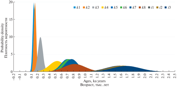
| Sample | Lat (dec°) | Lon (dec°) | Alt (masl) | 10Be (at/g) | 1s (at/g) | Shield, Corr | Density | Thick, Corr, | Er, (cm/yr) | Age (ka) | 1σ (ka) | 1σ without PR error |
|---|---|---|---|---|---|---|---|---|---|---|---|---|
| k1 | 43.2075 | 42.6857 | 2653 | 4049.4 | 626.3 | 0.984 | 2.75 | 3 | 0 | 0.14 | 0.02 | 0.02 |
| k2 | 43.2073 | 42.6856 | 2657 | 4436.3 | 394.1 | 0.9209 | 2.75 | 3 | 0 | 0.16 | 0.02 | 0.01 |
| k3 | 43.2190 | 42.6825 | 2231 | 5481.5 | 732.3 | 0.9573 | 2.75 | 3 | 0 | 0.25 | 0.04 | 0.03 |
| k4 | 43.2187 | 42.6825 | 2260 | 11 874.4 | 2766.4 | 0.9573 | 2.75 | 3 | 0 | 0.53 | 0.13 | 0.12 |
| k5 | 43.2182 | 42.6823 | 2260 | 15 154.4 | 1957.9 | 0.9209 | 2.75 | 3 | 0 | 0.7 | 0.11 | 0.1 |
| k6 | 43.2168 | 42.6825 | 2264 | 16 155.8 | 2135.2 | 0.9573 | 2.75 | 3 | 0 | 0.72 | 0.11 | 0.1 |
| k7 | 43.2183 | 42.6820 | 2254 | 15 531.458 | 2010.3131 | 0.9209 | 2.75 | 3 | 0 | 0.77 | 0.11 | 0.11 |
| k8 | 43.2177 | 42.6818 | 2269 | 18 286.2 | 3505.3 | 0.9573 | 2.75 | 3 | 0 | 0.82 | 0.18 | 0.17 |
| i1 | 43.2941 | 42.5694 | 2520 | 38 891.9 | 4055.4 | 0.9573 | 2.75 | 3 | 0 | 1.57 | 0.23 | 0.19 |
| i2 | 43.2942 | 42.5691 | 2506 | 39 991 | 4071.5 | 0.9573 | 2.75 | 3 | 0 | 1.63 | 0.23 | 0.2 |
| i3 | 43.2943 | 42.5694 | 2518 | 41 152.6 | 4011.1 | 0.9573 | 2.75 | 3 | 0 | 1.68 | 0.24 | 0.24 |
Sample preparation and AMS measurement. All samples were processed at CEREGE (Aix-en-Provence, France). Samples were crushed and sieved to collect the 250–1000 µm fraction. Quartz was first concentrated by magnetic separation and then isolated by successive leaching in a H2SiF6/HCl mixture. The obtained quartz fraction was leached at least 3 times in a 10% HF – 10% HNO3 solution in order to remove any remaining feldspars and to clean the grains from atmospheric 10Be. Purified quartz was completely dissolved in concentrated HF after addition of 150 µl of an in-house 9Be carrier solution (3025 ± 9 ppm; Merchel et al., 2008). Beryllium was extracted by successive alkaline precipitations of Be (OH)2 alternated with separation on anion and cation columns. Samples were then oxidized at 700 for 1 hour and the final BeO mixed with Nb powder and loaded into copper cathodes. AMS measurements of the 10Be/9Be ratios were conducted at the French national AMS facility ASTER (Arnold et al., 2010). Samples were calibrated against the in-house standard STD-11 (10Be/9Be = 1.191 ± 0.013 × 10⁻¹¹; Braucher et al., 2015) and a 10Be half-life of 1.387 ± 0.0012 × 10⁶ years (Chmeleff et al., 2010; Korschinek et al., 2010). Analytical uncertainties combine ASTER counting statistics, standard uncertainty, external uncertainty (0.5%; Arnold et al., 2010) and machine blank correction. 10Be sample concentration calculated from the corresponding 10Be/9Be ratio was corrected from associated chemical blanks. Scaling to the sample locations was made according to the recent, physically-based, LSD model (Lifton et al., 2014) which performs similarly to older empirical models (Borchers et al., 2016). Chosen parameters include the ERA40 atmospheric reanalysis (Uppala et al., 2005) and the VDM 2016 geomagnetic database. We retained the global production rate (PR) as no regional PR is available so far.
Exposure ages were computed with the online CREp program (Martin et al., 2017; http://crep.crpg.cnrs-nancy.fr) and are presented in Table 1. 10Be CRE ages are reported with 1σ “external” uncertainties, which include measurement, production rate and scaling uncertainties (e.g., Balco et al., 2008), in the main text and on the maps for better comparison with other proxies. Both internal and external uncertainties (including both analytical and production rate uncertainties) are reported in Table 1. For a given moraine, its assigned age corresponds to the weighted mean of the sample ages that successfully passed a Chi2 test (calculated with the internal uncertainties) used to identify outliers (Ward and Wilson, 1978). Based on field observations, we also considered the stratigraphic relationships to identify outliers.
RESULTS
Kashkatash Glacier (43.20N; 42.68E) is a cirque-valley glacier oriented to the North (#57 in USSR Glacier Inventory, 1970). According to USSR Glacier Inventory (1970) its length was 4.6 km, its area was 2.5 km2, and the front was located at 2600 m a.s.l. Detailed information on fluctuations of the Kashkatash Glacier based on instrumental, historical, lichenometric and tree-ring data was reported in Bushueva and Solomina (2012). We identified at least 13 terminal moraines within the distance of 900 meters from the Kashkatash Glacier front position in 2008. Three moraines were deposited between the 1870s and 1890s. In the 20th century the glacier advanced in the 1910-s, 1920-s, and 1960–1970-s.
In 2013 samples of grey granite boulders were collected from the surface of the moraines of the Kashkatash Glacier for 10Be analyses in the two locations with the most suitable conditions for sampling (see Fig. 1, Table 1). The limitation for CRE sampling in the Kashkatash valley is the dense forest cover that shades the surface of moraines and sometimes masks the shape of the moraine ridges. Many moraines are eroded and preserved in fragments vanishing and reappearing in the forest, some oldest generations are partly covered by debris flows.
Two 10Be samples (k1 and k2 at the Table 1) at the site A were collected at the right lateral moraines at the elevation 2653 and 2657 m asl, respectively. At the photo Fig. 2 one can clearly see several levels of lateral moraines preserved inside the highest moraine wall with sharp unvegetated inner slope and forested, more gently inclined outer one. The moraines were sampled where they were least eroded. The samples are coming from two moraine generations located very close to each other and looking very similar in terms of vegetation cover and erosion, so their deposition was most probably separated by a short period of time. It is impossible to precisely trace the connection of these generations with the corresponding frontal and left lateral moraines, but tentatively the A ridges (with the k1 and k2 dates) lead to those formed in 19th century before the 1880s – the position of the glacier front at the military topographic map. The k1 and k2 moraines yielded two 10Be CRE dates and 0.14 ± 0.03 ka and 0.16 ± 0.02 ka. Considering the statistical errors, the dates partly overlap and seem to correspond to the tree-ring age of the right lateral moraine dated by tree-rings to 1839–1840 CE (Bushueva and Solomina, 2012) (see the position of the tree at the Fig. 1).
Fig. 2.
Kashkatash Glacier terminus: 1– sites of 10Be sampling and dates in ka years reported in this paper; 2 – location of the tree damaged by the moraine (number mark the year of the first ring); 3 – moraines; 4 – limits of the glacier tongue in 1887–90 from the map and in 2022 from remote sensing data; 5 – sites mentioned in the text. Satellite image from GeoEye-1, acquired on 30.09.2022.
Рис. 2. Конец ледника Кашкаташ: 1 – пункты отбора образцов на анализ 10Be и результаты анализа – возраст в тысячах лет; 2 – местоположение дерева, повреждённого мореной (указан год образования первого кольца); 3 – морены; 4 – границы ледника в 1887–90 гг. по карте военных топографов и в 2022 г. по космическому снимку; 5 – поверхности, указанные в тексте статьи. Космический снимок с GeoEye-1, полученный 30.09.2022.
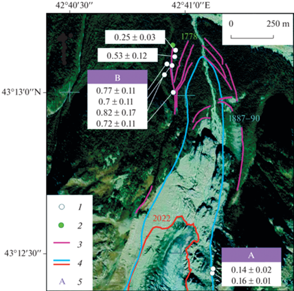
Other samples for 10Be were collected at the left side of the valley within an older moraine (point B), well-shaped, stretching along the left side of the valley composed of several nested ridges. From the distal side this compound rampart is limited by a debris flow noticeable due to a lighter tone at the space image (see Fig. 2). The pine forest covering the landform B is clearly more mature than the one spread out in the bottom of the valley: this is not only evident from tree ring dating (see Bushueva and Solomina, 2012) but distinguishable at the space images by a darker color of this site.
The rampart B was sampled for CRE dating in several locations at the elevation range from 2230 to 2270 m asl (see Table 1; Fig. 2). At least three moraine generations of different ages were identified using the 10Be CRE dating. The 10Be dates k3 0.25 ± 0.4 ka and k4 0.53 ± 012 ka (See Table 1) come from two moraines attached to the inner slope of the rampart B at the elevations approximately 2230 and 2260 m asl, respectively. These two generations of moraines depart from the inner slope of the rampart B close to the location of the tree tilted by a large block during a glacier advance that occurred in 1839–1840 CE (see Figs. 2; 4). The tilted tree is growing at the older moraine. Its first recorded ring dates back to 1778 CE i.e. the moraine was deposited at least in the 1760s (with the 15–20 years correction for the establishment of the tree). This tree-ring minimum date corresponds well to the 0.25 ± 0.4 ka 10Be date. Thus, another 10Be date is indirectly confirmed by the earlier tree-ring record (Bushueva and Solomina, 2012). Fig. 4
Fig. 3.
Kashkatash Glacier in 2009. Site A. Location of the sampling sites for k1 and k2 10Be (0.14+0.03 and 0.16 ± 0.02 ka). (Photo by I. Bushueva).
Рис. 3. Ледник Кашкаташ в 2009 г. Поверхность А. Местоположение отбора и возраст (в тысячах лет) образцов на анализ 10Be k1 и k2 (0.14 + 0.03 и 0.16 ± 0.02 тыс. лет) (Фото И.С. Бушуевой, август 2009 г.).
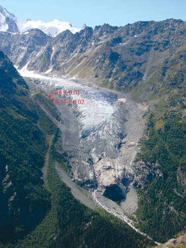
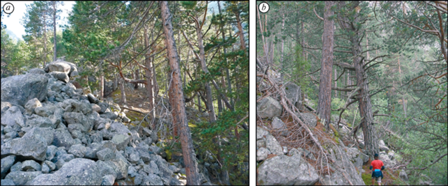
Fig. 4.
Kashkatash. Sampling site B: a – Inner slope of the moraine overlapped with a younger moraine that tilted a tree in 1839–1840 (Photo by O. Solomina, August 2009); b – Outer slope of oldest moraine B (Photo by O. Solomina, August 2008).
Рис. 4. Ледник Кашкаташ. Поверхность B: a – Внутренний склон морены с наложенной на неё более молодой мореной, которая повредила дерево в 1839–1840 гг. (Фото О.Н. Соломиной, август 2009 г.); b – Внешний склон старой морены (Фото О.Н. Соломиной, август 2008 г.).
Four exposure ages (samples k5–k8) from the stratigraphically oldest moraine at the Kashkatash range from 0.70 ± 0.11 to 0.82 ± 0.18 ka (see Table 1). The date from the outer slope of the rampart is slightly older (0.82 ± 0.18 ka) than three others, but the internal uncertainties of all samples overlap and thus the dates belong to the same population (Fig. 5). The age of this rampart is considered as a reliable one and different from all the other moraine surfaces. On the distal side of the rampart B, we dated living pine trees settled here before1689 CE marking the minimum age of this surface. The maximum diameter of lichens at this surface reached up to 85–120 mm, but due to the dense forest canopy and large scatter of lichen sizes, we do not consider these data reliable and useful for the surface age assessment.
Thus, even though the replication of the CRE dates of Kashkatash moraines is still poor and the dates are considered only as very preliminary ones, at least three generations of major advances can be tentatively identified as the mid 19th, mid 18th, and 13th centuries. They were of similar magnitude, although the precise locations corresponding to the front positions of these advances are not known. Judging by the size and the preservation of the oldest moraine the magnitude of the advance of 13th century was the largest one.
Irik Glacier (43.31N; 42.53E, #20 by USSR Glacier Inventory, 1970) descends from Elbrus Mt in a southeasterly direction. According to USSR Glacier Inventory its length in the late sixties was 9.8 km, the area was equal to 10.5 km2, the front was located at 2610 m a.s.l. Several maps and photographs show the shape and size of the glacier in 1887–1890 (Military Topographers, 1887–1890, 1:42.000 scale), in 1932 (Solovyev, 1934), in 1957 (topographic map), in the 1980s-early 2000s (Baume and Marcinek 1998; Zolotarev, 2009) (Fig. 6).
Fig. 6.
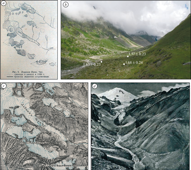
Irik Glacier and the valley: a – Map of Irik in early 1930s (Solovyev, 1931); b – Moraines of Irik Glacier (Photo by V.Jomelli, August 2013). At the foreground – the moraines of 19th century and moraines dated by 10Be at ca 1.6 ka.; c – Part of the map by Military Topographers, 1887–90; d – Irik valley in 1950s (Burakov, 1958 (Katalog…, 1970).
Рис. 6. Ледник Ирик и его долина: a – Карта ледника Ирик, начало 1930-х годов (Solovyev, 1931); b – Морены ледника Ирик (Фото В. Жомелли, август 2013). На переднем плане морены XIX века и морены, датированные с помощью космогенных изотопов 10Be 1.6 тыс. лет.; c – Фрагмент карты, сделанной корпусом военных топографов, 1887–90 гг.; d – Долина ледника Ирик (Фото Буракова, 1958 (Katalog…, 1970).
The positions of the glacier front and other important geomorphic details were described by numerous expeditions and surveys (Bush, 1914; Solovyev, 1934; Kovalev, 1961; Elbrus glaciation, 1968; Baume and Marcinek, 1998; Volodicheva and Voitkovsky, 2004). The most detailed sketch of glacier variations in the Late Holocene is provided by Baume and Marcinek (1998) and Volodicheva and Voitkovsky (2004). In this paper using a number of space images, old maps, descriptions and 10Be dates of moraines we produced a more comprehensive spatial high-resolution reconstruction of fluctuations of this glacier over the instrumental period and beyond this time.
The first historical data about the Irik Glacier was provided by Abikh who visited the valley in 1871. He noticed that the glacier was in the phase of its retreat from distinct crescent-shaped rampart of moraines (Volodicheva and Voitkovsky, 2004). According to his measurements, the glacier front was located at 2530 m a.s.l., however the estimate might be not very precise. At the Military Topographers Map which was compiled later (1887–1890) and is considered as a rather accurate one the glacier front is marked at the elevation 2541 m a.s.l. (see Figs. 6, 7).
Fig. 7.
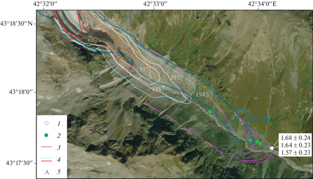
Fluctuations of Irik Glacier from remote sensing, historical, lichenometric and CRE data. 1 – sites of 10Be sampling and dates in ka years reported in this paper; 2 – location of lichens’ measurements and maximum diameter in mm; 3 – moraines; 4 – limits of the glacier tongue, year is marked by corresponding color; 5 – sites mentioned in the text. Satellite image from GeoEye-1, acquired on 12.09.2015.
Рис. 7. Колебания конца ледника Ирик по данным дистанционного зондирования Земли, историческим, лихенометрическим и космогенным изотопам: 1 – пункты отбора образцов на анализ 10Be и результаты анализа – возраст в тыс. лет; 2 – места измерения лишайников и их диаметр в мм; 3 – морены; 4 – границы ледника в разные годы, год указан соответствующим цветом; 5 –поверхности, указанные в тексте статьи. Космический снимок с GeoEye-1, полученный 12.09.2015.
We marked the positions of the front of the Irik Glacier map of Military Topographers at the Fig. 7. Although some of the old maps were compiled based on plane table surveying with specific defects causing some error in the identification of glacier margins (Tielidze, 2016), generally we do not question the elevation of the end of the glacier at the Military Topographers map. However the shape of the glacier tongue at this map looks strange: it is asymmetric and pressed against the left side of the valley. It is possible that it is reproduced incorrectly at the map due to the difficulties in identification of the glacier boundaries of the tongue covered with debris. Several authors (e.g. Kovalev, 1961, Volodicheva and Voitkovsky, 2004) noticed that the right side of the glacier tongue may represent the dead ice and, hence, it is shown at the maps and figures as a moraine rather than the glacier body. We also encountered these difficulties using space images while the tongue of Irik is currently covered by debris from the right side and the limit between the ice and the moraine from this side is unclear.
The military topographers map also shows three small glaciers above the right lateral moraine of the Irik Glacier. They still exist now (2022), but have significantly receded. The right lateral moraine of the Irik Glacier is eroded by their stream flows and debris; the surface above the moraine looks unstable, with very sparse vegetation.
According to the descriptions of Bush (1914) in 1911 the front of the Irik Glacier looked like a very high and steep wall, however Bush did not interpret these features as the evidence of glacier advance. Bush also indicated that the right lateral moraine covered a part of the glacier and merged with the median moraine of dark red color. This description confirms our suggestion about a potential cause of the error on the Map of Military Topographers who interpreted the part of the glacier ice as a moraine.
In 1926, Altberg (1928) found the mark of Rengarten installed in 1913 and identified a retreat of the Irik Glacier in 1913–1926 as 97 m. In 1929–1932 the Irik Glacier was surveyed by S.P. Solovyov (1934) who described the glacier itself and its valley in details. According to his data, Irik Glacier was retreating from the position mapped by the Military Topographers in 1887/90 to the year 1932 by approximately 200 m (Solovyov, 1934).
In 1956–1959 a stereophotogrammetric survey was carried out on the Irik Glacier (12.08.1956, 3.08.1958, 22.08.1959) (Elbrus glaciation, 1968 p. 279). During this period, the glacier snout “… on the right side receded by 72 m, of which in the first 2 years by 50 m, and in the third year – by 22 m. The order of magnitude of retreat in the left side of the glacier terminus is the same as in the right side… ”. The rates of retreat of the Greater Azau and Irik glaciers at that time were similar.
Our remote sensing data (Table 2) shows that between 1957 and 1987 the glacier lost 432 m in length. Between 1987 and 1997 it further retreated by 105 m, and between 1997 and 2015 – by another 265 m. As the glacier snout is covered by a surface moraine we also used the Sentinel 1 obtained on 18th and 30th of August, 2015 to assure the correctness of the identification of glacier boundaries in 2015. Between 2015 and 2022 Irik glacier retreated by 825 m.
Table 2.
Irik Glacier length and front elevation changes in 1887/90–2022 Таблица 2. Изменения длины и высоты конца ледника Ирик в 1887/90 – 2022 гг.
| Date | Source | Length Change, m | Front Elevation, m |
|---|---|---|---|
| 1.6 ka moraine | 10Be dating | 2490 | |
| –260 | |||
| 1887–90 | Map | 2506 | |
| –405 | |||
| 1930 | Map | 2542 | |
| –590 | |||
| 1945 | Aerial photo | 2603 | |
| –64 | |||
| 16.08.1957 | Aerial photo | 2605 | |
| –432 | |||
| 16.09.1987 | Aerial photo | 2632 | |
| –105 | |||
| 1997 | Aerial photo | 2649 | |
| –265 | |||
| 12.09.2015 | Space Image (GeoEye-1) | 2733 | |
| –825 | |||
| 28.08.2022 | Space Image (Pleiades) | 3010 | |
In July 30, 2008, when we visited the glacier it was retreating – its tongue was flat and covered with debris, the boundary between the dead ice and the body of the glacier was unclear. The terminal moraines of the Irik Glacier over the whole valley are poorly preserved due to excessive water erosion, avalanche, and debris flow activity. G.K. Tushinsky (Elbrus glaciation, 1968) also noticed that the rock deposits descending from the right side of the valley from the cirques that were supporting small glaciers in the late 19th century are not moraines, but solifluction flows and lobes that can be erroneously taken for the glacier deposits of the end of LIA. Between the positions of the glacier front in the 1930s and in 1945 we identified one reasonably well shaped moraine ridge (а) with a relatively stable undisturbed surface where we could measure lichens. In 2022 it supported a generation of lichens as large as 25–26 mm still including two outliers (34 and 37 mm) probably growing on the boulders transported from the older moraines at the left slope of the valley.
A moraine complex at the bottom of the valley that is located between 2495 and 2510 m a.s.l. and is composed of two to five ranges occupies a limited space 500–600 m long (see Fig. 6, b). Here two moraine ridges support lichens as large as 31 mm (b) and 41 mm (c). The location of moraine b is close to the position of the glacier at the Military Topographers map and, hence the surface had stabilized in the end of the 19th century. The outer ridge C might represent the moraine described by Abikh in 1871 as a “crescent-shaped rampart”. It is reasonable to suggest that it might be deposited a few decades before his visit in 1871, most probably in the mid 19th century, but since then it was substantially eroded. At present, it does not look like a “crescent-shaped rampart”, but represents a top-rounded eroded range up to 5–7 m high.
Seinova and Zolotarev (2001), identified stadial moraines at both sides of the Irik valley supporting the lichens as large as 33, 40, 50 and 64 mm that they attributed basing on their lichen growth rate to 1910, the 19th century, late 18th, and late 17th centuries. Unfortunately, they did not provide a map or other details of the location of these moraines, so a comparison with our results is difficult, but the lichens at two moraines described above seem to correspond to the earlier measurements of Seinova and Zolotarev (2001).
Below the moraine c, a few ridges of similar appearance are located (stage d). One more clearly shaped, stable, and less eroded than the other moraine ridges was sampled for 10Be age in 2013 by V. Jomelli. It returned three 10Be ages (1.57 ± 0.23 ka, 1.63 ± 0.23 ka, and 1.68 ± 0.24 ka). The dates are close to each other and mark the advance that occurred at ca ~1.6 ka (see Fig. 7). The sampled moraine is one of the outermost eroded ridges on the left side of the valley located at the elevation of about 2490 m a.s.l.
Outside of this moraine there is a distinct fluvioglacial terrace 10–45 m high that ends at 2300 m a.s.l. composed of unsorted rounded boulders of volcanic and crystalline rocks cemented by laminated sands (Baume, Marcinek 1998). Baume and Marcinek tentatively attributed it to the “Historical” time that traditionally dates back to ca 2 ka in the Elbrus area, although in fact these moraines were never dated. By several morphological evidences (stable flattened surface, well-developed soil cover, large width, and considerable length), this terrace must be much older than the 1.6 ka moraine and its age probably exceeds the Late Holocene limits. It was noticed that the moraine of “Fernau” maximum advance contacts this terrace (Baume, Marcinek 1998). However, this is incorrect as between the position of glacier in the 19th century and the beginning of the terrace there is at least one Late Holocene moraine (ca 1.6 ka).
Thus, since the first description in 1871 the Irik Glacier was mostly retreating. The linear retreat between 1880 and 2015 was 1860 m, the rise of the front elevation is 230 m. Two glacier maxima occurred in the past two millennia in the 19th century and ca 1.6 ka and these advances were of similar magnitude (2030 m and 2190 m, respectively, in comparison with the year 2015). The second advance was however slightly larger.
DISCUSSION
We believe that despite of limited number of 10Be dates that we report here the history of Late Holocene glaciation in Central Caucasus became clearer. However, we have to admit that the dates of moraines reported here are of different reliability what depends not only on the number of the dates for each moraine, but also on geomorphic setting. In the case of complex morphology of moraine ridges and their fragmentary preservation (e.g. at the Kashkatash Glacier) is might be difficult to distinguish between the landforms of different generations. Some of moraine ridges at the Kashkatash Glacier were also covered by forest and it was difficult to precisely identify in the field whether our sampling sites belong to the same or different stages of glacier advances. Moreover, at the site B, at the Kashkatash Glacier numerous generations of debris flows covered the distal side of the main moraine rampart adding uncertainties to the stratigraphic and genetic identifications of the secondary ranges adjacent to it. In the case of the Irik Valley, the identification of the isolated moraine ridges where we sampled was not difficult, but we cannot exclude potential renovation of the surface while the sampled ridges were rather low, of smooth soft shape and supporting limited number of crustose lichens.
10Be dates of moraines of the Irik and Kashkatash glaciers, although limited and very preliminary, allow the identification of five maxima of glacier advances of similar magnitude that occurred around 1.62, 0.75, 0.53, 0.25 and 0.16–0.14 ka (i.e. in 4th–5th, 13th, 15th, 18th and early-mid 19th centuries CE). The dates are more credible when several closely intersecting 10Be dates are coming from the same moraine or (and) the CRE dates are supported by another source of chronological information (historical, tree-rings, 14C). When the confident dates come from different glaciers one can suggest that the event was of regional value and is relevant to paleoclimatic context.
Advance at 1.6 ka (4th–5th centuries CE). The advance of the Irik Glacier that is dated by three very close 10Be ages of moraine (1.57 ± 0.23 ka, 1.63 ± 0.23, and 1.68 ± 0.24 ka) is identified in the Caucasus for the first time. It is not confirmed by other evidence. Lichenometry was not useful in this case: the number of lichens on this surface is rather limited and the largest thallii are 52–53 mm, that is equal to several hundred years only judging by our preliminary growth curve (Solomina et al., 2016). The lack of large lichens is a warning signal that the moraine surface might be eroded, and the date can be rejuvenated. However, a close intersect of the three dates is rather a positive sign indicating the significance of the average date.
Traditionally previous studies identified two major Late Holocene advances in the Caucasus that occurred in the LIA and two thousand years ago that they called “Historical stage” (Turmanina, 1971; Tushinsky and Turmanina, 1979; Zolotarev, 2009). The age estimate is based on the descriptive geomorphic evidence, speculations, and analogues with other mountain regions where the Late Holocene moraines were dated. Thus, the 10Be date of the Irik moraine (1.6 ± 0.23 ka) seems to be a possible analogue of the “historical” stage of glacier advances in the Caucasus described in literature.
In the section of paleosols interlayed with tills of the Azau Glacier (Solomina et al., 2022) one of four major advances recorded in these sediments is dated by 14C to the 7th–9th centuries CE. This till is several centuries younger than the 10Be date of the moraine at the Irik Glacier (4th–5th centuries CE) and therefore even considering the potential analytical errors it probably characterizes a different period of glacier advances in the Caucasus. No closer analogues of the advance at 1.6 ka are found so far in the Caucasus.
In the Swiss Alps, the glacier area in 5th century was similar to the end of 20th century, while the glaciers reached their maximum of the 1st millennium CE later, in the 6th – early 7th centuries (Holzhauser et al., 2005; Le Roy et al., 2015). In the Italian Alps, the phase of advances started earlier and continued through the 5th to 9th century CE (Deline and Orombelli, 2005). This might be a case similar to the Elbrus area. In the Himalaya-Tibetan monsoon area Yang et al. (2008) basing on multi-proxy data established a period of glacier advance at around CE 200-600, while Murari et al. (2014) confirmed the advance in the region at 500 ± 200 CE by 10Be dating. These dates are closer to our dates of Irik Late Holocene moraines (CE 4th–5th centuries CE). Taking in consideration the dating uncertainties, these advances might be correlative with the Late Antique LIA cooling that was documented by tree rings in the Alps, Altay, and some other temperate regions in Eurasia in 536 to ~660 CE (Büntgen et al., 2016).
The paleoclimatic context for the period 1.6 ka in the Caucasus is unknown, because the temporal resolution for the available reconstructions (e.g. Grachev et al., 2021) is not enough to recognize the events of centennial duration. However, we noticed an interesting coincidence that might explain the climatic background of the advance of 1.6 ka. In Lake Garabashi, located in a neighboring valley a fraction of sediments was laminated indicating that in the period of their formation the small lake did not dry out. Three radiocarbon dates (1505 + 20, 1650 + 20, 1760 ± 20 years BP) (Shishkov et al., 2019; Alexandrin, personal communication) constrain this episode of more humid and possibly colder climate that led to the permanent waterproofing of the lake. Judging by the number of preserved layers it lasted for about 100 years.
Advance at 0.7–0.8 ka (13th century CE). Four 10Be dates (0.7 + 0.11, 0.72 ± 0.11, 0.77 ± 0.11, and 0.82 ± 0.18 ka) are obtained for the left lateral moraine of the Kashkatash Glacier. This time (13th century CE) is known as the first stage of the LIA and the evidence of glacier advances at that time was reported for many regions including those that are based on direct historical descriptions (Grove, 2012). In the Northern Caucasus at the Donguz-Orun glacier left lateral moraine yielded a 10Be date 0.77 ± 0.1 ka (Solomina et al., 2018). Although the date is single it supports our 10Be Kashkatash dates of moraines at 0.7–0.8 ka. At the southern slope of Caucasus in Georgia a left lateral moraine of Chalaati Glacier yielded two 10Be dates as 0.67 ± 0.1 and 0.79 ± 0.08 ka (Tielidze et al., 2020). The dates of this moraine partly overlap with those of the Kashkatash moraine. Based on spore-pollen and geochemical analysis of the deposits of Lake Karakel (Teberda valley) Alexandrin at al. (2023) identified the beginning of the LIA cooling in the Caucasus in ca 1250–1400 CE that corresponds to the timing of glacier advances mentioned above.
The advance at 0.53 ka (15th century CE). Only one moraine at Kashkatash Glacier dating back to 15th century (0.53 ± 0.13 ka) was obtained so far. For this reason, it cannot be considered as a reliable one at the moment. However, in the sediments of Lake Karakel a second cold minimum (1500–1630 CE) begins roughly at that time. In the section “Azau Star” one till layer was deposited between 1490s and 1640s (Solomina et al., 2016). It is quite possible that the new evidence of this advance will be found in the future in the Caucasus.
This advance is documented in the Alps. Schimmelpfennig et al. (2014) at Steingletscher reported numerous 10Be ages in stratigraphic order distinguishing four LIA glacier culminations at about 1470, 1650, 1750 and 1820 CE. For the LIA in the European Alps Nicolussi et al. (2022) proposed the subdivision of LIA in three phases: early 1260–1380 CE, intermediate 1380–1575 CE and a main 1575–1860 CE. The moraine at Kashkatash of 15th century may correspоnd to the intermediate phase of advances in the scheme of Nicolussi.
The advances at 0.25 ka and 0.16–0.14 ka (18th and 19th centuries CE). The 10Be date 0.25 ± 0.04 ka at Kashkatash moraine is also single, but it is indirectly supported by tree ring minimum date at the moraine of the same glacier (Bushueva and Solomina, 2012). At the Alibek and Tseia glaciers we found 220–300 year old trees growing at the moraines that are located in the vicinity of those of the19th century, but this minimum age might be very different from the real time of deposition of the moraines (Solomina et al., 2016). In the Lake Karakel sediment-based reconstruction the last LIA cooling period that might correspond to the culmination of glacier advances in the Caucasus occurred at ca 1750–1880 CE (Alexandrin et al., 2023). In the paleosol section this period of advances dates back to 1680–1850s CE.
The 10Be dates of the last LIA maximum (0.16–0.14 ka) at the Kashakatash Glacier is supported by tree-ring dates at Kashkatash and other glaciers (Solomina et al., 2016), tree-ring summer temperature and mass balance reconstruction (Dolgova, 2016) and paleosol section at Greater Azau (Solomina et al., 2022). It coincides with the advance of the Greater Azau Glacier (Elbrus area) in 1849 CE known from direct historical description of Abich.
In their global review Solomina et al. (2016) indicated that the mountain glacier advances in the past two millennia cluster in 200s–300s, 400s–600s, 800s, 1000, 1150s, 1280s, 1350s, 1400s, 1450s, 1600s, 1640s, 1680s, 1720s, 1770s, 1820s, 1850s–1860s, 1890s, 1900s–1920s, 1970s–1980s and 1990s CE. In this paper, using the new 10Be dates we demonstrated that in the Northern Caucasus some periods of glacier advances (e.g. in 4–5th, 13th, 15th, 18th and early-mid 19th centuries CE) may be synchronized with this global pattern.
CONCLUSIONS
In this study, we presented 10Be ages from the Irik and Kashkatash glaciers, northern Greater Caucasus. The new dataset allowed us for the first time to identify moraine deposition of these glaciers in 4–5th, 13th, 15th, 18th, and early mid-19th centuries CE, which is consistent with the global pattern of mountain glacier advancement over the past two millennia. The new evidence shows that the advances of the first millennium CE of the Irik Glacier were slightly larger than those of the later glacier maxima (in the 19th century CE). At Kashkatash the oldest and most prominent moraine that was identified and dated by 10Be was formed at the first stage of the LIA (in the 13th century CE). Although precise area of the glacier at that time is unknown, it is clear that the glacier shape and size were only slightly larger than those of the second LIA maximum in the 19th century. Due to a limited number of 10Be dates we consider our data presented here as very preliminary and hope that in the nearest future more detailed studies in this direction will allow to increase the credibility and accuracy of the reconstructed glacier and climate history in this region.
Acknowledement. We are grateful to our French colleagues of the Aix-Marseille University, CNRS, for the introduction of this method in the Caucasus. The ASTER AMS national facility (CEREGE, Aix-en-Provence) is supported by the INSU/CNRS, the ANR through the “Projets thematiques d’excellence” program for the “Equipements d’excellence” ASTER-CEREGE action and IRD. We thank our colleagues Dr. Ekaterina Dolgova, Dr. Vladimir Mikhalenko, and Dr. Vladimir Matskovsky continuous efforts in sampling, processing the samples in the lab. and statistical analyses. The field works were supported by the framework (No 0148-2019-0004) of the State Assignment of Institute of Geography, Russian Academy of Sciences. The Megagrant project (agreement No 075-15-2021-599, 8.06.2021) of the Ministry of Highest Education of Russia “Natural and Anthropogenic Environmental Changes Inferred From Multi-Proxy Paleorecords. In Russia” supported the analyses of the data and writing of this paper.
Благодарности. Мы благодарим наших французских коллег из Университета Экс-Марсель, Марсель, Франция за внедрение метода космогенных изотопов на Кавказе. Мы благодарны нашим коллегам Екатерине Долговой, Владимиру Михаленко и Владимиру Мацковскому за их усилия по отбору, подготовке и анализу образцов в лаборатории. Они также принимали участие в полевых работах и любезно предоставили данные по дендрохронологическому датированию и статистическому анализу. Полевые работы выполнены в рамках темы государственного задания Института географии No 0148-2019-0004. Анализ данных и написание статьи проведены в рамках Мегагранта № 075-15-2021-599 от 08.06.2021 г.
Список литературы
Alexandrin M.Y., Solomina O.N., Darin A.V. Variations of heat availability in the Western Caucasus in the past 1500 years inferred from a high-resolution record of bromine in the sediment of Lake Karakel. Quatern. International. 2023. https://doi.org/10.1016/j.quaint.2023.05.020
Altberg V.J.O Sostoyanii lednikov Elbrusa i Glavnogo Kavkazskogo khrebta v basseine reki Baksan v period 1925–1927 godov. About the state of glaciers of Elbrus and the Greater Caucasus mountain range in the basin of Baksan River during 1925–1927. Ottisk iz Izvestij GGI. Proc. of the State Hydrological Institute. 1928, 22:79 –89. [In Russian].
Arnold M., Merchel S., Bourlès D.L., Braucher R., Bene-detti L., Finkel R.C., Aumaître G., Gottdang A., Klein M. The French accelerator mass spectrometry facility ASTER: improved performance and developments Nuclear Instrumentation Methods in Physics Research Section B: Beam Interactions with Materials and Atoms. 2010, 268: 1954–1959.
Balco G. Contributions and unrealized potential contributions of cosmogenic-nuclide exposure dating to glacier chronology, 1990–2010. Quaternary Science Reviews. 2011, 30 :3–27.
Balco G. Glacier Change and Paleoclimate Applications of Cosmogenic-Nuclide Exposure Dating. Annual Review of Earth and Planetary Sciences 2020, 48 (1): 21–48. https://doi.org/10.1146/annurev-earth-081619-05260
Balco G, Stone J.O, Lifton N.A, Dunai T.J. A complete and easily accessible means of calculating surface exposure ages or erosion rates from 10Be and 26Al measurements. Quat Geochronol. 2008, 3: 174–195.
Baume O., Marcinek J. Gletscher und Landschaften des Elbrusgebietes. Die Lawienentatigkeit. Verlag Gotha, Gotha. 1998 [In German].
Borchers Brian, Marrero S., Balco G., Caffee M., Goehring B., Lifton N., Nishiizumi K., Phillips F., Schaefer J., Stone J. Geological calibration of spallation production rates in the CRONUS-Earth project. Quaternary Geochronology. 2016, 31: 188–198.
Bush N.A.O Sostoyanii lednikov severnogo sklona Kavkaza v 1907, 1909, 1911 i 1913 godah. About state of glaciers of the Northern slope of the Caucasus in 1907, 1909, 1911 and 1913. Izvestiya Imperatorskogo geograficheskogo obschestva po obschey geografii. IRGO notes on general geography. 1914, 50 (5–9): 461–510 [In Russian].
Büntgen U., Myglan V.S., Ljungqvist F.C., McCormick M., Di Cosmo N., Sigl M., Kirdyanov A.V. Cooling and societal change during the Late Antique Little Ice Age from 536 to around 660 AD. Nature geoscience. 2016, 9 (3): 231–236. https://doi.org/10.1038/ngeo2652
Bushueva I.S., Solomina O.N., Jomelli V. History of Alibek Glacier based on Earth remote sensing images, bioindication and cosmogenic (14C and 10Be). Led i Sneg. Snow and Ice. 2015, 55 (3): 97–106. [In Russian].https://doi.org/10.15356/2076-6734-2015-3-97-106
Bushueva I.S., Solomina O.N. Kolebaniya lednika Kashkatash za poslednie chetire stoletiya po kartograficheskim, dendrohronologicheskim i lichenometricheskim dannim. Fluctuations of Kashkatash Glacier over last 400 years using cartographical, dendrochronological and lichonometrical data. Led i sneg. Ice and Snow. 2012, 2 (118): 121–130 [In Russian].https://doi.org/10.15356/2076-6734-2012-2-121-130
Braucher R., Guillou V., Bourlès D.L., Arnold M., Aumaître G., Keddadouche K., Nottoli E. Preparation of Aster in-house 10Be/9Be standard solutions. Nuclear Instruments and Methods in Physics Research. 2015, 361: 335–340.
Chmeleff J., von Blanckenburg F., Kossert K., Jakob D. Determination of the 10Be half-life by multicollector ICP-MS and liquid scintillation counting. Nucl. Instrum. Methods Phys. Res. 2010, Sect. B 268 (2), 192–199. https://doi.org/. 09.012https://doi.org/10.1016/j.nimb.2009
Deline P., Orombelli G. Glacier fluctuations in the western Alps during the Neoglacial, as indicated by the Miage morainic amphitheatre (Mont Blanc massif, Italy). Boreas. 2005, 34: 456–467. https://doi.org/10.1080/03009480500231369
Dolgova E. June–September temperature reconstruction in the Northern Caucasus based on blue intensity data. Dendrochronologia. 2016, 39: 17–23. https://doi.org/10.1016/j.dendro.2016.03.002
Grachev A.M., Novenko E.Y., Grabenko E.A., Alexand-rin M.Y., Zazovskaya E.P., Konstantinov E.A., Solomina O.N. The Holocene paleoenvironmental history of Western Caucasus (Russia) reconstructed by multi-proxy analysis of the continuous sediment sequence from Lake Khuko. The Holocene. 2021, 31 (3): 368–379. https://doi.org/10.1177/0959683620972782
Grove J.M. Little Ice Ages: Ancient and Modern. 2004. Vol. 1 and 2, 2nd ed. London, New York: Routledge. https://doi.org/10.1017/S0016756805400771
Holzhauser H., Magny M., Zumbühl H.J. Glacier and lake-level variations in west-central Europe over the last 3500 years. Holocene. 2005, 15 (6): 789–801. https://doi.org/10.1191/0959683605hl853ra
Hormes A., Müller B.U., Schlüchter C. The Alps with little ice: evidence for eight Holocene phases of reduced glacier extent in the Central Swiss Alps. The Holocene. 2001: 255–265. https://doi.org/10.1191/095968301675275728
Jomelli V., Grancher D., Naveau P., Cooley D., Brunstein D. Assessment study of lichenometric methods for dating surfaces. Journ. of Geomorphology. 2007, 86 (1–2): 131–143. https://doi.org/10.1016/j.geomorph.2006.08.010
Jomelli V., Francou B. Comparing characteristics of rockfall talus and snow avalanche landforms in an alpine environment using a new methodological approach. Geomorphology. 2000, 35: 181–192.
Katalog lednikov SSSR. USSR Glacier Inventory. V. 8. North Caucasus. Pt. 5. Basins of Malka and Baksan rivers. Leningrad: Hydrometeoizdat, 1970: 145 p. [In Russian].
Korschinek Gunther, Bergmaier A., Faestermann T., Gerstmann U.C., Knie K., Rugel G., Wallner A. A new value for the half-life of 10Be by heavy-ion elastic recoil detection and liquid scintillation counting. Nuclear Instruments and Methods in Physics Research Section B: Beam Interactions with Materials and Atoms. 2010, 268 (2): 187–191.
Kovalev P.V. Sovremennoe oledenenie basseina reki Baksan. Modern glaciation of the Baksan River basin. Materiali kavkazskoi ekspedicii po programme MGG. Data of Caucasian expedition by the program of International Geophysical Year. 1961, 2: 3–106 [In Russian].
Le Roy M., Nicolussi K., Deline P., Astrade L., Edouard J.L., Miramont C., Arnaud F. Calendar-dated glacier variations in the Western European Alps during the Neoglacial: the Mer de Glace record, Mont Blanc massif. Quaternary Science Reviews. 2015, 108: 1–22. https://doi.org/10.1016/j.quascirev.2014.10.033
Lifton N., Sato T., Dunai T.J. Scaling in situ cosmogenic nuclide production rates using analytical approximations to atmospheric cosmic-ray fluxes. Earth Planet. Sci. Lett. 2014, 386: 149–160. https://doi.org/10.1016/j.epsl.2013.10.052
Martin L.C.P., Blard P.H., Balco G., Lavé J., Delunel R., Lifton N., Laurent V. The CREp program and the ICE-D production rate calibration database: A fully parameterizable and updated online tool to compute cosmic-ray exposure ages. Quaternary geochronology. 2017, 38: 25–49.
Merchel S., Arnold M., Aumaître G., Benedetti L., Bourlès D.L., Braucher R., Alfimov V., Freeman S.P.H.T., Steier P., Wallner A. Towards more precise 10Be and 36Cl data from measurements at the 10−14 level: Influence of sample preparation. Nuclear Instruments and Methods in Physics Research Section B: Beam Interactions with Materials and Atoms. 2008, 266 (22): 4921–4926. https://doi.org/10.1016/j.nimb.2008.07.031
Military Topographers Map, 1887–1890. 1:42 000, Office of military topographers, 4th Cartographic Factory Geokartprom, Rostov-Don.
Murari M.K., Owen L.A., Dortch J.M., Caffee M.W., Dietsch C., Fuchs M., Haneberg W.C., Sharma M.C., Townsend-Small A. Timing and climatic drivers for glaciation across monsoon-influenced regions of the Himalayan-Tibetan orogen. Quaternary Science Reviews. 2014, 88C: 159–182. https://doi.org/10.1016/j.quascirev.2014.01.013
Nicolussi K., Roy M.L., Schlüchter C., Stoffel M., Wacker L. The glacier advance at the onset of the Little Ice Age in the Alps: New evidence from Mont Miné and Morteratsch glaciers. The Holocene. 2022, 32 (41): 09596836221088247. https://doi.org/10.1177/09596836221088247
Oledenenie El’brusa. Elbrus glaciations / Ed. G.K. Tushinskiy. Moscow: MSU, 1968: 345 p. [In Russian].
Uppala, Sakari M., Kållberg P.W., Adrian J., Simmons U. Andrae V., Bechtold Da Costa, Fiorino M., Gibson J.K. The ERA-40 re-analysis. Quarterly Journal of the Royal Meteorological Society: A journal of the atmospheric sciences, applied meteorology and physical oceanography. 2005, 131 (612): 2961–3012.
Prirodnye processy na territorii Kabardino-Balkarii. Environmental processes in the territory of Kabardino-Balkaria. Moscow–Nal’chik: RAS, 2004: 438 p. [In Russian].
Schimmelpfennig I., Schaefer J.M., Akçar N., Koffman T., Ivy-Ochs S., Schwartz R., Schlüchter C. A chronology of Holocene and Little Ice Age glacier culminations of the Steingletscher, Central Alps, Switzerland, based on high-sensitivity beryllium-10 moraine dating. Earth and Planetary Science Letters. 2014, 393: 220–230. https://doi.org/10.1016/j.epsl.2014.02.046
Shishkov V.A., Kuderina T.M., Mikhalenko V.N., Kuzmenkova N.V., Zazovskaya E.P., Solomina O.N. Garabashi lake as a paleoarchive (Elbrus area, Caucasus). Geophysical Research Abstracts. 2019, 21. EGU2019-15885-2. EGU General Assembly. CC Attribution 4.0 license.
Seinova I.B., Zolotarev E.V. Ledniki i seli Prielbrusiya. Glaciers and debris flows of vicinity of the Mt. Elbrus. Moscow: Nauchnyj mir. The scientific world. 2001 [In Russian].
Solomina O.N., Alexandrovskiy A.L., Zazovskaya E.P., Konstantinov E.A., Shishkov V.A., Kuderina T.M., Bushueva I.S. Late-Holocene advances of the Greater Azau Glacier (Elbrus area, Northern Caucasus) revealed by 14C dating of paleosols. The Holocene. 2022, 32 (5): 468–481. https://doi.org/10.1177/09596836221074029
Solomina O.N., Bushueva I.S., Polumieva P.D., Dolgova E.A., Dokukin M.D. History of the Donguz-Orun Glacier from bioindication, historical, cartographic sources and remote sensing data. Led i Sneg. Ice and Snow. 2018, 58 (4): 448–461 [In Russian].https://doi.org/10.15356/2076-6734-2018-4-448-461
Solomina O.N., Bushueva I.S., Dolgova E.A., Jomelli V., Alexandrin M.J., Mikhalenko V.N., Matskovsky V.V. Glacier variations in the Northern Caucasus compared to climatic reconstructions over the past millennium. Glob. Planet change. 2016, 140: 28–58. https://doi.org/10.1016/j.gloplacha.2016.02.008
Solomina O.N., Bushueva I.S., Volodicheva N.A., Dolgova E.A. Age of moraines of the Bolshoy Azau Glacier in the upper course of the Baksan River valley according to dendrochronological data. Led i Sneg. Ice and Snow. 2021, 61 (2): 271–290 [In Russian].https://doi.org/10.31857/S2076673421020088
Solovyev S.P. Izuchenie lednikov Severngo Kavkaza za 25 let (1907–1932 goda). Study of glaciers on the Northern Caucasus over 25 years (1907-1932). Izvestiya Gosudarstvennogo geograficheskogo obshchestva. Proc. of the State Geographical Society.1934, 66 (4): 525–555 [In Russian].
Tielidze L.G. Glacier change over the last century, Caucasus Mountains, Georgia, observed from old topographical maps, Landsat and ASTER satellite imagery. The Cryosphere, 2016, 10: 713–725. https://doi.org/, 2016https://doi.org/10.5194/tc-10-713-2016
Tielidze L.G., Solomina O.N., Jomelli V., Dolgova E.A., Bushueva I.S., Mikhalenko V.N., Brauche R., ASTER Team. Change of Chalaati Glacier (Georgian Caucasus) since the Little Ice Age based on dendrochronological and Beryllium‑10 data. Led i Sneg. Ice and Snow. 2020, 60 (3): 453–470. https://doi.org/10.31857/S2076673420030052
Turmanina V.I. Perspektivy primenenija fitoindikacionnyh metodov v gljaciologii. Perspectives of applying phytoindicational methods in glaciology. In: Tushinskiy G.K. (Ed.), Fitoindikacionnye metody v gljacilogii. Phytoindication methods in glaciology. Moscow: MGU Press, 1971: 5–19 [In Russian].
Tushinsky G.K. Glyatsiologicheskie raboti na Elbruse. Glaciological studies on the Elbrus. Informatsionniy sbornik o rabotah po Mejdunarodnomu geofizicheskomu godu. Informational collection on the studies of the International Geophysical Year. Moscow: PUBLISHER, 1958: 3–28 [In Russian].
Tushinsky G.K., Turmanina V.A. Rhytms of the glacial processes of the past millennium. In Rhytms of the glacial processes. Moscow: MSU, 1979: 154–159.
Volodicheva N.A., Voitkovskiy K.F. Evolutsiya lednikovoi sistemi Elbrusa. Evolution of Elbrus glacial system. In: Konischev V.I., Saf’yanov G.A. (Eds.). Geografiya, obschestvo i okrujauschaya sreda. Struktura, dinamika i evolutsiya prirodnih geosystem. Geography, society and environment. Structure, dynamics and evolution of natural geosystems. Moscow: Gorodets, 2004: 44–50 [In Russian].
Ward, Greame K., Wilson S.R. Procedures for comparing and combining radiocarbon age determinations: a critique. Archaeometry. 1978, 20 (1): 19–31.
Yang B., Brauning A., Dong Z., Zhang Z., Keqing J. Late Holocene monsoonal temperate glacier fluctuations on the Tibetan Plateau. Global and Planetary Change 2008, 60: 126–140. https://doi.org/10.1016/j.gloplacha.2006.07.035
Zolotarev E.A. Evolutsiya oledeneniya Elbrusa. Evolution of Elbrus glaciation. Moscow: Nauchnyj mir. The scientific world. 2009. [In Russian].
Дополнительные материалы отсутствуют.