

Исследование Земли из Космоса, 2023, № 5, стр. 45-57
Литосферные магнитные аномалии по данным спутниковой миссии CHAMP над западным гималайским синтаксисом и окружающими территориями
Д. Ю. Абрамова a, Л. М. Абрамова b, *
a Институт земного магнетизма, ионосферы и распространения радиоволн им. Н.В. Пушкова РАН
Троицк, Москва, Россия
b Центр геоэлектромагнитных исследований Института физики Земли им. О.Ю. Шмидта
Троицк, Москва, Россия
* E-mail: labramova@igemi.troitsk.ru
Поступила в редакцию 15.03.2023
- EDN: XGGMCN
- DOI: 10.31857/S0205961423050020
Аннотация
Исследуется распределение литосферных магнитных аномалий над территорией Индо-Азиатской коллизии, в частности, области Тарима и Западного Гималайского синтаксиса (WHS), полученных по измерениям на германском спутнике Земли CHAMP в разные годы его миссии. Приводятся карты литосферных магнитных аномалий модуля полного вектора Ta для этих областей. Обсуждается отражение в аномальном магнитном поле последствий процесса субдукции Индийской литосферной плиты под Евразийскую плиту в контексте современных представлений о региональной геолого-тектонической структуре и геофизике. Наблюдаемое на картах Ta изменение знака аномалий магнитного поля над северной частью Индийской плиты трактуется как результат мантийного прогрева нижней коры, подъема изотермы Кюри и, как следствие, потери исходной намагниченности низов земной коры. С целью детального изучения территории WHS и его окружения построены карты литосферного магнитного поля на возможно более низком уровне орбиты CHAMP, что позволило увеличить их разрешение за счет приближения к источникам поля. Обсуждается связь выявленных региональных аномалий с тектоническими процессами в этой сейсмически активной области и другими имеющимися к настоящему времени геофизическими данными. Интерпретация полученной информации показала, что образы литосферных магнитных аномалий четко коррелируют с современными представлениями о расположении крупномасштабных геолого-тектонических структур.
ВВЕДЕНИЕ
Тектонические процессы, связанные с горообразованием при столкновении (субдукции) континентов, сыграли фундаментальную роль в геолого-тектонической эволюции Земли и являются предметом геологических, геофизических и геохимических исследований на протяжении последних ста лет. Тектоника плит, предложенная А. Вегенером в двадцатых годах прошлого столетия (Вегенер, 1925), дала объяснение многим особенностям и деталям современной геологической структуры и тектонической истории нашей планеты.
Литосферные магнитные аномалии (ЛМА) связаны со свойствами тектонических структур на больших глубинах и являются отражением геолого-тектонического строения самых нижних частей земной литосферы. Существенным преимуществом для построения и анализа карт магнитного поля над территориями, где затруднены, а зачастую и невозможны, приземные наблюдения, таких, например, как высокогорные системы Гималаев, Памира, Гиндукуша и Тянь-Шаня, является возможность использования для анализа и интерпретации огромных массивов спутниковых геомагнитных данных (Абрамова и др., 2022а, 2022б). На сегодняшний день это один из наиболее высокоточных, дешевых и доступных геофизических методов изучения глубинного строения нашей планеты.
Наиболее информативными при этом оказываются материалы геомагнитной съемки низколетящих околоземных спутников, в частности, германского спутника CHAMP (Reigber et al., 2002). Продолжавшаяся более чем 10 лет миссия аппарата позволила покрыть практически всю поверхность планеты равномерной сетью наблюдений. Высота полета CHAMPа в разные годы находилась в интервале 480–250 км над поверхностью геоида, что позволяет получать наборы экспериментальных данных для исследования структуры ЛМА на разных уровнях наблюдения над земной поверхностью.
Пространственное распределение аномального магнитного поля, полученное по измерениям спутников на высоте их орбит, можно рассматривать как некоторую региональную характеристику, указывающую на закономерности распределения различных типов крупных магнитных неоднородностей в литосфере. Тщательный анализ построенных на уровнях орбит карт литосферного магнитного поля показал, что такие наблюдения малочувствительны к приповерхностным геологическим структурам. В рассматриваемом диапазоне высот полета спутников фиксируются практически только низкочастотные литосферные магнитные аномалии интенсивностью от первых единиц до первых десятков нТл с пространственными размерами порядка 200–400 км, сравнимыми с высотой измерений (Hemant et al., 2005). Существенно, что при этом отфильтровываются локальные магнитные аномалии, связанные с намагниченными породами, находящимися в верхних слоях земной коры. Таким образом, карты ЛМА, построенные по спутниковым данным, содержат информацию о современной намагниченности именно глубинных слоев литосферы, являясь образами региональных тектонических структур, и, кроме того, отражают геотермическую обстановку в их пределах (Gao et al., 2016).
Соответственно, параметры ЛМА, отражающие положение тектонических структур и их физические свойства, можно использовать для комплексных исследований совместно с другими геолого-геофизическими методами.
Исследования показывают, что крупномасштабные тектонические единицы – щиты, кратоны и зоны субдукции характеризуются положительными аномалиями (вызванными повышенной магнитной восприимчивостью), а бассейны и абиссальные равнины – отрицательными магнитными аномалиями, возникновение которых объясняется утонением коры и поднятием изотермы Кюри (Hemant et al., 2005).
Спутниковые карты ЛМА разных территорий, как правило, хорошо согласуются с выдвигаемыми геолого-геофизическими гипотезами и региональными моделями строения литосферы. Однако в некоторых регионах земного шара обнаруживаются несоответствия между предсказанными и измеренными значениями аномального поля. В частности, это проявляется при изучении погруженных под молодые платформы или осадочные слои древних дорифейских областей и активных магматических зон (Hemant et al., 2005). Такие аномалии часто указывают на закономерности распределения различных типов магнитных неоднородностей на большой глубине, свидетельствуют о “просвечивании” древних структур.
Зоны сочленения магнитных областей, по-видимому, являются отражением глубинных и долгоживущих разломов, на которых развивались авлакогены и депрессии.
В данной работе мы анализируем карты ЛМА над частью территории Восточной Азии, построенные по наблюдениям германского спутника CHAMP, которые были получены в 2008 и 2010 гг., а также исследуем связь аномалий со строением литосферы этого активного в тектоническом отношении региона, где происходит современное взаимодействие тектонических плит: Евразийской, Тихоокеанской, и Индийской.
Развиваемые нами технологии выделения литосферной части из измеренного спутниковыми магнитометрами суммарного магнитного поля, позволяют достаточно точно определять положение региональных магнитных аномалий, обусловленных намагниченностью глубоко погруженных слоев литосферы.
Для решения задачи было необходимо:
– собрать, обобщить и привести к удобной для дальнейшей обработки форме данные геомагнитного поля, измеряемые спутником в околоземном пространстве;
– используя специально разработанные технологии, выделить из огромных массивов данных составляющие, наиболее адекватно характеризующие литосферное магнитное поле;
– построить карты распределения аномального магнитного поля региона;
– провести интерпретацию выделенных магнитных аномалий, сопоставить полученные результаты с имеющимися для этих областей геофизическими и геолого-тектоническими данными.
МЕТОДИКА ОБРАБОТКИ СПУТНИКОВЫХ ДАННЫХ
Основная проблема при получении адекватных параметров ЛМА состоит в корректном разделении суммарного магнитного поля, измеренного спутником CHAMP, на составляющие, связанные с физическими источниками, генерирующими эти поля, и выделении части, связанной с полем ЛМА, путем исключения из измеренных значений “ненужных” составляющих. Разумеется, удаляемые части поля, должны быть максимально адекватно описаны с помощью существующих на сегодняшний день математических моделей.
Технологии выделения литосферной части из измеренного суммарного магнитного поля, успешно проверены и были использованы ранее для построения карт ЛМА в различных регионах (Абрамова Д., Абрамова Л., 2014; Абрамова и др. 2020; 2022а, 2022б).
Процесс выделения региональных ЛМА из спутниковых измерений магнитного поля сводится к следующим шагам:
– выбор из массивов экспериментальных данных, материалов, относящихся к изучаемой территории, их обобщение и приведение к удобной для дальнейшей обработки форме;
– выделение (с использованием специально разработанных технологий) из полученных массивов данных составляющей, наиболее адекватно характеризующей именно литосферное аномальное магнитное поле;
– создание баз данных отдельных компонент аномального магнитного поля;
– построение карт пространственного распределения компонент аномального магнитного поля над заданной территорией.
В настоящее время в целях упрощения процесса обработки больших массивов информации, основываясь на большом опыте работы со спутниковыми материалами, мы дополнительно проводим тщательный предварительный отбор экспериментальных данных. Для анализа используются измерения поля только для витков, совершаемых спутником в ночное время (LT от 22:00 до 6:00 ч), и только в спокойные в магнитном отношении дни (магнитные индексы kp ≤ 1 и Dst≤ 20). Оценки показали, что данный подход не приводит к понижению точности определения значений аномального поля и существенно снижает время обработки.
Для анализа распределения ЛМА над изучаемой территорией были выделены и обработаны в соответствии с описанной выше методикой массивы геомагнитных данных спутника CHAMP за два года (2008 и 2010 гг.) его миссии, равномерно покрывающие сектор 60°–100° E и 20°–44° N.
Большой объем материала позволил получить детальную информацию о пространственном распределении ЛМА модуля полного вектора аномального магнитного поля Ta на различных уровнях наблюдения от ~350 до ~260 км.
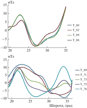
На рис. 1 показаны примеры изменения значений Ta вдоль широты для нескольких витков полета спутника, полученныe в результате обработки измеренных данных. Представлены серии графиков Ta для пролета спутника над двумя областями: Центральной (вверху) и Западным Гималайским синтаксисом11 WHS (внизу). Числовой индекс кривой обозначает приблизительное значение долготы, над которой пролегала орбита спутника.
Рис. 1.
Пример изменения значений полного вектора аномального литосферного магнитного поля Та, вдоль витков спутника CHAMP над двумя областями: Индо-Азиатской коллизии: Центральной (вверху) и WHS (внизу). Обозначение каждой кривой – округленное значение долготы орбиты; горизонтальная шкала широта, градусы, вертикальная шкала – значение поля, нТл.
Для исследуемой территории на основе измерений CHAMPа была создана база данных объемом порядка ~12 тыс. измерений каждой компоненты и модуля полного вектора поля, что позволяет эффективно использовать ее с целью последующего построения карт магнитных аномалий различных масштабов и различных степеней осреднения поля по площади.
При интерпретации карт ЛМА всегда уточняется вопрос надежности выделяемых аномалий, а именно, соответствует ли их детальность масштабу основных тектонических структур. В данной ситуации это делалось путем построения карт по нескольким независимым выборкам данных, благо спутниковые наблюдения предоставляют их в большом количестве. Только после того как аномалия воспроизводится в каждой из этих попыток и подтверждена как надежная, мы допускаем возможность ее интерпретации.
ГЕОЛОГО-ТЕКТОНИЧЕСКИЕ ОСОБЕННОСТИ СТРОЕНИЯ ИНДО-АЗИАТСКОЙ КОЛЛИЗИИ
Структура строения западной части исследуемой области, окружающей Западный Гималайский синтаксис, обусловлена, в основном, воздействием Индийской тектонической плиты, которое приводит к сокращению и поднятию Тибетского плато и образованию мощных горных систем, таких как Гималаи, Памир и Гиндукуш. Этой территории присущи очень сложная поверхностная топография, активные деформации земной коры и мощная сейсмическая и вулканическая активность (Wang et al., 2001).
На рис. 2 приведена карта, представляющая главные геологические черты изучаемого региона. Показанная область имеет чрезвычайно сложную структуру литосферы, составленную группами складчатых поясов, террейнов и кристаллических массивов (микроконтинентов) с докембрийским фундаментом (Добрецов и др., 2013).
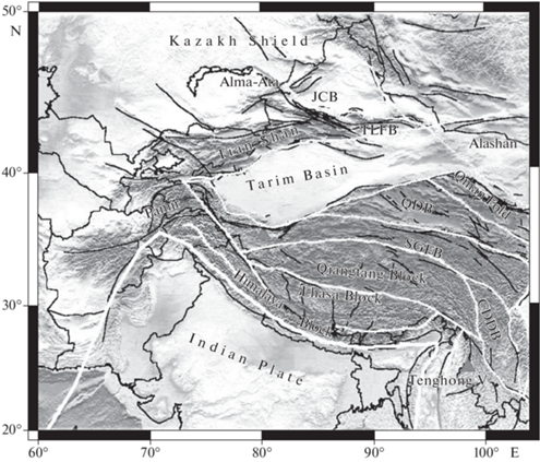
Тектоническая активность здесь проявляется до сих пор, а ее природа приписывается межплитному взаимодействию и (или) мантийным процессам. Последствия этих процессов исследуются геологическими и геофизическими методами, привлекая внимание ученых всего мира (Molnar et al., 1987; Nelson et al., 1996; Yin, Harrison, 2000; Tapponnier et al., 2001; Wang et al., 2001; Huang, Zhao, 2006; Zhao, 2009; Bai et al., 2010; Sobel et al., 2011).
Обширные геолого-тектонические и геофизические исследования показали, что Индийская плита (ИП) погружается под Тибетское плато под относительно небольшим углом до глубин 200–300 км. Расстояние по горизонтали от края субдуцирующей плиты составляет 500–700 км. Ее северный край к настоящему времени достиг блока Квантанг (QB). По данным GPS движение Индийской плиты относительно Евразийской на территории всего Тибетско-Гималайского орогена происходит с равномерной скоростью ~4 см/ год (Zhang et al., 2004; Huang, Zhao, 2006).
В связи с этим, тектоносфера характеризуется существенной пространственной неоднородностью и рядом ярких аномалий геофизических полей.
АНОМАЛЬНОЕ ЛИТОСФЕРНОЕ МАГНИТНОЕ ПОЛЕ НАД ТЕРРИТОРИЕЙ ИНДО-АЗИАТСКОЙ КОЛЛИЗИИ
Для целостного восприятия положения Западного Гималайского синтаксиса (WHS), расположенного в западной части территории Индо-Азиатской коллизии, рассмотрим построенную карту ЛМА для всей этой области и сделаем краткий обзор процессов, протекающих в ее пределах.
На рис. 3 показана карта Та на высоте ~350 км над территорией, ограниченной координатами 24°–42° N и 64°–100° E, полученная авторами по измерениям спутника CHAMP, выполненным в течение 2008 г. При построении использовано медианное осреднение по блокам размером 100 × 100 км средствами GMT, blockmedian. (Wessel, Smith, 2007).
Рис. 3.
Ta над территорией Индо-Азиатской коллизии на высоте ~350 км. Аббревиатуры: IP, Индийская плита; HIMF, Гималаи; TIB, Тибет; AFGB, Афганский блок; PM, Памир; TAR, Тарим; TDJB, Таджикский блок; QB, Квантангский блок; WHS, EHS, Западный и Восточный синтаксисы, соответственно. Черная жирная линия показывает границы субдуцирующей Индийской плиты.
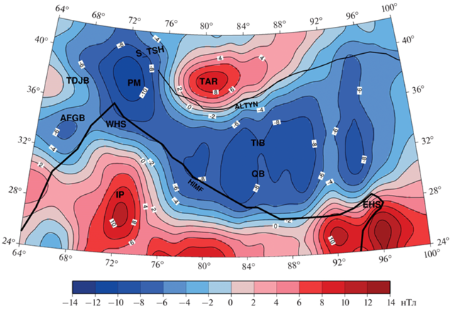
На юге и юго-западе региона прослеживается масштабная положительная ЛМА, топографически приуроченная к территории субдуцирующей Индийской плиты, ее границы обозначены черной жирной линией. На рис. 3 видно, что в обозначенных границей плиты пределах положительные значения магнитного поля фиксируются только над южной и юго-западной частями, а севернее происходит смена знака значений аномального поля с положительного на отрицательный.
Объяснение этого факта, по-видимому, состоит в следующем. Согласно имеющейся к настоящему времени гипотезе, описывающей происходящие здесь тектонические процессы, предполагается, что в верхней мантии над погруженной частью Индийской плиты образуется крупный мантийный клин. Вследствие этого горячий мантийный поток, а также поток флюидов, образующихся при глубинной дегидратации погружающейся части, вызывают подъем нагретого астеносферного материала, что приводит к утонению литосферы под этой территорией (Huang, Zhao, 2006).
Этот процесс вызывает значительные аномалии геофизических полей в литосфере: области повышенных и пониженных сейсмических скоростей, чрезвычайно высокие значения теплового потока, аномалии электропроводности и магнитного поля.
Известно, что повышение теплового потока вызывает прогрев намагниченных пород нижней части земной коры до температуры ~580°, так называемой точки Кюри магнетита, когда исчезают их магнитные свойства (Lowes, 2007). В полосе широт порядка 24°–28° N наблюдается (рис. 3) линейная зона высокого градиента аномального магнитного поля. К югу от нее находится область плиты со значительной исходной намагниченностью нижней коры, однако севернее при погружении плиты происходит ее прогрев, подъем поверхности Кюри, что приводит к потере магнитных свойств. Эту градиентную зону, разделяющую области положительных и отрицательных аномалий, можно рассматривать как индикатор разности температур в нижней части земной коры: выше и ниже 580°C.
Центральное пространство на карте занимает обширная отрицательная ЛМА над территорией Тибета и окружающими его областями.
Тектоносфера Тибето-Гималайского орогена, сложившаяся в результате сложных глобальных тектонических процессов, характеризуется существенной пространственной неоднородностью. Здесь происходит прогрев литосферы, подъем поверхности Кюри, потеря магнитных свойств минералов нижней коры, и, как следствие, наблюдаются пониженные значения литосферного магнитного поля над всей территорией Тибета.
В северной части карты выделяется яркая положительная магнитная аномалия с центром с координатами ~38° N/80° E над Таримской котловиной, расположенной на севере Тибетского нагорья. Тарим имеет форму линзы и окружен орогенными поясами, в его основании лежит докембрийский фундамент, перекрытый фанерозойским осадочным чехлом (Li, Mooney, 1998; Lu et al., 2008; Li et al., 2011; Gao, Fan, 2014). Точные границы фундамента неизвестны. Таримскую котловину оконтуривает разлом Алтын-Таг (тонкая черная линия на рис.3), имеющий протяженность ~2000 км, который образует северо-западную границу Тибетского нагорья с Таримской котловиной.
Интересно поведение границ положительной ЛМА над Таримской котловиной, довольно четких с западной и южной сторон, но с достаточно медленным изменением значений амплитуды поля, вытянутых в направлении к северо-востоку. Полученный результат указывает на то, что Таримский кристаллический массив не ограничен, как принято считать, областью “линзы”, а имеет продолжение на северо-восток, т.е. “просвечивается” из-под осадочной толщи посредством аномального литосферного магнитного поля.
ЛМА НАД ТЕРРИТОРИЕЙ ЗАПАДНОГО ГИМАЛАЙСКОГО СИНТАКСИСА
Для более детального анализа характеристик ЛМА над территорией, ограниченной координатами 28°–42° N/64°–80° E, и включающей Западный Гималайский синтаксис (WHS), а также окружающие его области, были обработаны геомагнитные данные спутника CHAMP за 6 мес. 2010 г.
Эти дополнительные материалы, полученные в период плавного снижения аппарата до высоты ~260–270 км, относящиеся ко времени окончания его “жизни”, дали возможность построить распределение ЛМА с более хорошим разрешением благодаря приближению уровня измерений к источникам магнитного поля в литосфере. На базе этих данных была построена серия карт компонент ЛМА исследуемой территории различных масштабов и параметров осреднения.
Западный Гималайский синтаксис, называемый также Памирским выступом, расположенный на северо-западе Тибетского нагорья возник, по современным представлениям, в результате столкновения самой северной оконечности субдуцирующей Индийской плиты с Евразийской плитой (Burtman, Molnar, 1993; Negredo et al., 2007; Sobel et al., 2011).
Сложно построенный в геолого-тектоническом плане WHS, а также прилегающие к нему области, в последние десятилетия являются предметом активных геолого-тектонических и геофизических исследований (Kosarev et al., 1993; Roecker et al., 1993; Ghose et al., 1998; Lei et al., 2002; Tiwari et al., 2009; Yang et al., 2009; Gao et al., 2016).
Общее представление о сложной тектонике этой области дает карта, приведенная на рис. 4 (Koulakov, Sobolev, 2006).
Рис. 4.
Рельеф и основные тектонические особенности WHS и прилегающих территорий, (Koulakov, Sobolev, 2006).
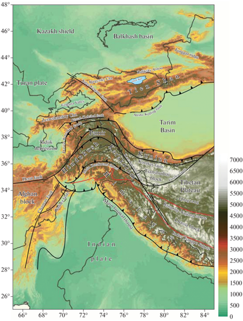
Западный Гималайский синтаксис (Памирский выступ) соединяет Гималаи с горами Тянь-Шань и отделяет котловину Тарим от Таджикского бассейна.
Движение Индийской плиты смещало ранее образовавшиеся коллизионные горы на север, где протянулась горная система Тянь-Шаня − сложный палеозойский ороген, активизировавшийся в течение неогена (Windley et al. 1990; Sobel et al., 2006). Столкновение Индийской плиты и Таджикско-Таримского бассейна разделило последний, первоначально непрерывный, на две части. Отделенный Таджикский бассейн, в основе которого лежит триасовая или юрская континентальная кора (Tapponnier et al., 1981; Burtman, Molnar, 1993; Brookfield, Hashmat, 2001) сейчас расположен к западу от WHS. К востоку от WHS находится рассмотренный в предыдущем разделе Таримский бассейн.
По мере движения Индийской плиты на север в течение последних 10 млн лет, WHS быстро развивался (Dewey et al., 1989). Ориентация разломов и геологических структур в синтаксисе Западных Гималаев и прилегающей к нему территории указывает на то, что в процессе продвижения на север Индийская плита блокируется жесткими Таримским бассейном на востоке и Таджикским бассейном на западе. Коровый материал плиты, вклиниваясь между этими двумя бассейнами, погружается под них, приводя к поднятию горной системы Памира, расположенной на самой северо-западной окраине Индо-Азиатской коллизионной зоны, вблизи WHS.
В регионе Тянь-Шаня и Памира часто происходят мощные землетрясения, это наиболее сейсмически активные области в Центральной Азии. Синтаксис и его окрестности являются одной из наиболее активных областей с мощной сейсмичностью (Koulakov, Sobolev, 2006; Mechie et al., 2012).
Геологические исследования показывают также, что Тянь-Шань имеет очень сложное строение с наличием множества типов пород, что обусловлено происходившими в его геологической истории частыми и сложными тектоническими движениями, сопровождаемыми крупномасштабными извержениями вулканов. Интенсивная сейсмическая активность, значительные деформации земной коры в Тянь-Шаньском орогенном поясе могут быть связаны со сложной структурой и тектоникой в верхней мантии под этой областью. Это отражено в работах многих исследователей глубинной структуры и динамических процессов Тянь-Шаньского орогенного пояса (Chen et al., 1997; Cotton, Avouac, 1994; Ghose et al., 1998; Kosarev et al., 1993).
Рассмотреть, как особенности геолого-тектонического строения такого сложного региона и происходящих здесь процессов отражаются в образах поля литосферных магнитных аномалий, представляется, безусловно, интересным.
На рис. 5 представлено пространственное распределение ЛМА над западной частью Индо-Евразийской коллизионной зоны, в которую входит область WHS, на примере модуля полного вектора аномального магнитного поля Ta.
Рис. 5.
Ta над территорией WHS на высоте 260 км. Аббревиатуры: IP, Индийская плита; TIB, Тибет; PMR, Памир; TAR, Тарим; TDZ, Таджикский блок; AFG, Афганский блок; S_TSH, Южный Тянь-Шань; WHS, Западный Гималайский синтаксис. Разломы: QMF, Киа Ман; SPF, Южный Памирский; MPF, Средний Памирский; NPF, Северный Памирский; MD, Май Данг; KPF, Ке Пин; KKF, Качи Куньлунь; HIMF, Гималаи. Черной жирной линией обозначена граница Индийской плиты.
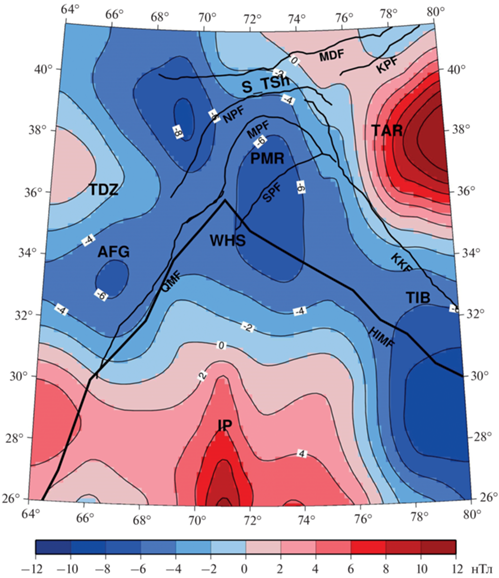
Рисунок 5 демонстрирует, что в литосферном магнитном поле на уровне ~260 км наблюдается необычайно сложная мозаичная структура крупных положительных и отрицательных аномалий. Рассмотрим их подробнее.
Крупная положительная ЛМА на юге приурочена к области, движущейся в северном направлении Индийской плиты (IP) (обозначена жирной черной линией). Амплитуда аномалии плавно понижается на север и, по мере приближения к WHS, меняет знак на отрицательный.
В полосе широт порядка 32°–33° N наблюдается зона высокого градиента аномального магнитного поля. К югу от нее, как и в случае ЛМА центральной части Индо-Евроазиатской коллизии, нижняя кора плиты обладает значительной исходной намагниченностью. Однако севернее коровый материал плиты при ее погружении прогревается, как сказано ранее, мантийным теплом, что вызывает повышение температуры намагниченных пород нижней части земной коры до ~580°, так называемой точки Кюри магнетита, и потерю магнитных свойств. Эти процессы, по-видимому, присущи всей территории, связанной к Индо-Евроазиатской коллизией.
Построенное распределение поля ЛМА хорошо коррелирует с образами литосферных аномалий сейсмических скоростей, полученных по результатам сейсмических исследований (ГСЗ, томографии и др.) (Kosarev et al., 1993; Gao, Huang, 2000; Koulakov, Sobolev, 2006). Индийская плита на этих разрезах отчетливо отображается как высокоскоростная зона, погружающаяся под Тибетское плато до глубин 200–300 км.
Небольшая по величине положительная ЛМА над Таджикским блоком имеет овальную форму с плавным уменьшением амплитуды к востоку и, так же как в случае Индийской плиты, по мере приближения к WHS ее значения переходят в отрицательную область.
Несколько иначе выглядит западная часть положительной ЛМА над Таримом: в удаленной от WHS части она характеризуется, как и должно быть, существенными положительными значениями, но по мере приближения к области раздела с Таджикским бассейном границы магнитной аномалии принимают ступенчатый вид, и далее происходит плавный переход значений в отрицательную область. Ступенчатость перехода, возможно, обусловлена наличием в западной части Тарима поясов торошения и дробления отдельных блоков земной коры в местах его взаимодействия с Индийской плитой, что характерно для такого рода образов ЛМА в других активных зонах (Абрамова Д., Абрамова Л., 2014, Абрамова и др., 2019).
Распределение поля ЛМА, полученное по геомагнитным наблюдениям спутника CHAMP, демонстрирует, что вся огромная горная область, охватывающая территории Памира, южной части складчатой системы Тянь-Шаньского рифтогенного пояса, Афганского и Восточной части Таджикского блоков, а также западной части Тибетского плато, характеризуется отрицательными значениями. Особенность такого распределения ЛМА объясняется интенсивным движением Индийской плиты на север, столкновением и погружением ее под Таримский и Таджикский бассейны и, соответственно, прогревом намагниченного вещества коры процессами, проходящими глубоко в астеносфере.
Пониженные значения ЛМА хорошо согласуются с оценками положения уровня поверхности Кюри в этом регионе на глубинах менее 32 км (Gao et al., 2015; 2016), где магнитные минералы переходят из ферромагнитного состояния в парамагнитное. Это максимально проявляется в аномальном магнитном поле над территорией Памира, непосредственно над WHS, где наблюдается исключительно четкая отрицательная ЛМА.
Интересно, что всем зонам раздела архейских блоков, а именно, разломам QMF, KKF, MDF, KPF и, в особенности, складчатым областям, таким как Южный Тянь-Шань (S_TSH), свойственны пониженные уровни литосферного магнитного поля, что, по-видимому, также обусловлено сокращенной мощностью магнитоактивного слоя.
Сейсмические исследования, выполненные в этом районе, показывают, что наиболее яркие отрицательные скоростные аномалии наблюдаются на глубинах до 100–150 км в литосфере Тибета и Памира и до глубин 80–120 км – в литосфере Тянь-Шаня (Koulakov, Sobolev, 2006). Именно в этих же областях зафиксированы наиболее интенсивные отрицательные литосферные аномалии, что еще раз подтверждает реалистичность полученных пространственных распределений аномального магнитного поля.
ВЫВОДЫ
Анализ карт спутниковых литосферных магнитных аномалий над территорией Индо-Азиатской коллизии, и, в частности, области Тарима и Западного Гималайского синтаксиса, показывает, что параметры аномального геомагнитного поля отражают пространственное строение современных крупномасштабных геолого-тектонических структур исследуемой области.
Показано, что область высокого градиента ЛМА между южной и северной частями субдуцирующей Индийской плиты является индикатором положения зоны в которой вследствие мантийных процессов разогрева астеносферы происходит потеря магнитных свойств ферро-магнитных минералов, составляющих нижнюю кору Земли.
Можно сделать заключениe о целесообразности использования спутникового литосферного магнитного аномального поля в условиях труднодоступных высокогорных регионов при изучении тектоносферы сложно построенных и геодинамически активных регионов на примере западной части Индо-Азиатской коллизии.
Список литературы
Абрамова Д.Ю., Абрамова Л.М. Литосферные магнитные аномалии на территории Сибири (по измерениям спутника СНАМР) // Геология и геофизика. 2014. Т. 55. С. 1081–1092.
Абрамова Д.Ю., Абрамова Л.М., Варенцов И.М., Филиппов С.В. Исследование литосферных магнитных аномалий Гренландско-Исландско-Фарерского вулканического комплекса по данным измерений на спутнике CHAMP // Геофизические исследования. 2019. Т. 20(2). С. 5–18. https://doi.org/10.21455/gr2019.2-1
Абрамова Д.Ю., Филиппов С.В., Абрамова Л.М. О возможностях использования спутниковых геомагнитных наблюдений в исследовании геолого-тектонического строения литосферы // Исслед. Земли из космоса. 2020. № 2. С. 69–81. https://doi.org/10.31857/ S0205961420010029
Абрамова Д.Ю., Абрамова Л.М., Варенцов И.М. Аномальное литосферное магнитное поле над территорией Индо-Азиатской коллизии по данным спутника CHAMP // Исслед. Земли из космоса. 2022а. № 3. С. 55–65. https://doi.org/10.31857/S0205961422030022
Абрамова Д.Ю., Филиппов С.В., Абрамова Л.М., Варенцов И.М. Литосферные магнитные аномалии над территориями крупных магматических провинций // Геофизические процессы и биосфера. 2022б. Т. 21. № 1. С. 33–42. https://doi.org/10.21455/GPB2022.1-2
Вегенер А. Происхождение материков и океанов. В кн.: Современные проблемы естествознания. М.: “Госиздат”, 1925. 145 с.
Добрецов Н.Л., Кулаков И.Ю., Полянский О.П. Геодинамика, поля напряжений и условия деформаций в различных геодинамических обстановках // Геология и геофизика. 2013. Т. 54. № 4. С. 469–499.
Bai D., Unsworth M.J., Meju M.A., Ma X., Teng J., Kong X., SunY., Sun J., Wang L., Jiang C., Zhao C., Xiao P., Liu M. Crustal deformation of the eastern Tibetan plateau revealed by magnetotelluric imaging // Nat. Geosci. Lett. 2010. V. 3. P. 358–362. https://doi.org/10.1038/NGEO830S
Brookfield M.E., Hashmat A. The geology and petroleum potential of the North Afghan platform and adjacent areas (northern Afghanistan, with parts of southern Turkmenistan, Uzbekistan and Tajikistan // Earth-Sci. Rev. 2001. V. 55. P. 41–71.
Burtman V.S., Molnar P. Geological and geophysical evidence for deep subduction of continental crust beneath the Pamir // GSA Spec. Pap. 1993. V. 281. P. 1–76.
Chen Y., Roecker S., Kosarev G. Elevation of the 410-km discontinuity beneath the central Tien Shan: Evidence for a detached lithospheric root // Geophys. Res. Let. 1997. V. 24. P. 1531–1534.
Cotton F., Avouac P. Crust and upper-mantle structure under the Tian Shan from surface wave dispersion // Phys. Earth Planet Inter. 1994. V. 84. P. 1–4.
Dewey J.F., Cande S., Pitman W.C. The tectonic evolution of the India/Eurasia collision zone // Eclogae Geol. Helv. 1989. V. 82. P. 717–734.
Gao Z., Fan T. Intra-platform tectono-sedimentary response to geodynamic transition along the margin of the Tarim Basin, NW China // J. Asian Earth Sciences. 2014. V. 96. P. 178–193. https://doi.org/10.1016/j.jseaes.2014.08.023
Gao G., Kang G., Li G., Bai C. Crustal magnetic anomaly and Curie surface beneath Tarim Basin, China, and its adjacent area // Canadian J. Earth Sciences. 2015. V. 52(6). https://doi.org/10.1139/cjes-2014-0204
Gao G., Kang G., Li G., Bai C., Wu Y. An analysis of crustal magnetic anomaly and Curie surface in west Himalayan syntaxis and adjacent area // Acta Geod. et. Geoph. 2016. https://doi.org/10.1007/s40328-016-0179-z
Gao R., Huang D., Lu D. Deep seismic reflection profile across the juncture zone between the Tarim basin and the west Kunlun mountains // Chin Sci. Bull. 2000. V. 45. P. 2281–2286.
Ghose S., Hamburger W., Virieux J. Three-dimensional velocity structure and earthquake locations beneath the northern Tian Shan of Kyrgyzstan, central Asia // J. Geophys. Res. 1998. V. 103. P. 2725–2748.
Hemant K., Maus S., Haak V. Interpretation of CHAMP crustal field anomaly maps using a geographical information system (GIS) technique // Earth Observation with CHAMP: Results from Three Years in Orbit. 2005. P. 249–254.
Huang J., Zhao D. High-resolution mantle tomography of China and surrounding regions // J. Geophys. Res. 2006. V. 111. B09305. https://doi.org/10.1029/2005JB004066
Kosarev G.L., Petersen N.V., Vinnik L.P., Roecker S.W. Receiver functions for the Tien Shan analog broadband network: Contrasts in the evolution of structures across the Talasso-Fergana fault // J. Geophys. Res. 1993. V. 98. P. 4437–4448.
Koulakov I., Sobolev S. A tomographic image of Indian lithosphere break-off beneath the Pamir-Hindukush region // Geophys. J. Int. 2006. V. 164. P. 425–440.
Lei J., Zhou H., Zhao D. 3-D velocity structure of P-wave in the crust and upper-mantle beneath Pamir and adjacent region // Chin J. Geophys. 2002. V. 45. P. 802–811.
Li S., Mooney W.D. Crustal structure of China from deep seismic sounding profiles // Tectonophysics. 1998. V. 288. P. 105–113. https://doi.org/10.1016/S0040-1951(97) 00287-4
Li Z., Chen H., Song B., Li Y., Yang S., Yu X. Temporal evolution of the Permian large igneous province in Tarim Basin in northwestern China // J. Asian Earth Sciences. 2011. V. 42. P. 917–927.https://doi.org/10.1016/j.jseaes.2011.05.009
Lowes F. Geomagnetics spectrum, spatial. In: Gubbins D., Herrero-Bervera E. (eds) Encyclopedia of geomagnetism and paleomagnetism. 2007. Springer. Berli. P. 350–353.
Lu S., Li H., Zhang C., Niu G. Geological and geochronological evidence for the Precambrian evolution of the Tarim Craton and surrounding continental fragments // Precambrian Res. 2008. V. 160. P. 94–107. https://doi.org/10.1016/j.precamres.2007.04.025
Mechie J., Yuan X., Schurr B., Schneider F., Sippl C., Ratschbacher L., Minaev V., Gadoev M., Oimahmadov I., Abdybachaev U., Moldobekov B., Orunbaev S., Negmatullaev S. Crustal and uppermost mantle velocity structure along a profile across the Pamir and southern Tien Shan as derived from project TIPAGE wide-angle seismic data // Geophys. J. Int. 2012. V. 188. P. 385–407.
Molnar P., England P., Martinod J. Mantle dynamics, the uplift of the Tibetan Plateau, and the Indian monsoon // Rev. Geophys. 1987. V. 31. P. 357–396.
Negredo A., Replumaz A., Villasenor A., Guillot S. Modeling the evolution of continental subduction processes in the Pamir-Hindu Kush region // Earth Planet Sci. Lett. 2007. V. 259. P. 212–225. https://doi.org/10.1016/j.epsl.04.043
Nelson K., Zhao W., Brown L. Partially molten middle crust beneath southern Tibet: Synthesis of Project INDEPTH results // Science. 1996. V. 274. P. 1684–1696.
Reigber C., Lühr H., Schwintzer P. CHAMP mission status. 2002. Advances in Space Research V. 30 (2). P. 129–134. https://doi.org/10.1016/S0273-1177(02)00276-4
Roecker S., Sabitova M., Vinnik L., Bormakov A., Golvanov I., Mamatkanova R. Three-dimensional elastic wave velocity structure of the western and central Tian Shan // J. Geophys. Res. 1993. V. 98. № 15. P. 779–795.
Sobel E.R., Chen J., Heermance R.V. Late Oligocene-Early Miocene initiation of shortening in the Southwestern Chinese Tian Shan: implications for Neogene shortening rate variations // Earth Planet Sci Lett. 2006. V. 247. P. 70–81.
https://doi.org/10.1016/j.epsl.2006.03.048
Sobel E., Schoenbohm L., Chen J., Thiede R., Stockli D., Sudo M., Strecker M. Late Miocene-Pliocene deceleration of dextral slip between Pamir and Tarim: implications for Pamir orogenesis // Earth Planet Sci. Lett. 2011. V. 304. P. 369–378. https://doi.org/10.1016/j.epsl.2011.02.012
Tapponnier P., Mattauer M., Proust F., Cassaigneau C. Mesozoic ophiolites, sutures, and large-scale tectonic movements in Afghanistan // Earth Planet Sci Lett. 1981. V. 52. P. 355–371.
Tapponnier P., Zhiqin X., Roger F., Meyer B., Arnaud N., Wittlinger G., Jingsui Y. Oblique stepwise rise and growth of the Tibetan plateau // Science. 2001. V. 294. P. 1671–1677.
Tiwari V.M., Rajasekhar R.P., Mishra D.C. Gravity anomaly, lithospheric structure and seismicity of west Himalayan syntaxis // J. Seismol. 2009. V. 13. P. 363–370.
Wang Q., Zhang P., Freymueller J., Bilham R., Larson K. Present-day crustal deformation in China constrained by global positioning system measurements // Science. 2001. V. 294. P. 574–577.
Wessel P., Smith W.H.F. The generic mapping tools. Technical reference and cookbook version 4.2., 2007. https://doi.org/gmt.soest.hawaii.edu
Windley B.F., Allen M.B., Zhang C., Zhao Z., Wang G. Paleozoic accretion and Cenozoic redeformation of the Chinese Tien Shan Range, central Asia // Geology. 1990. V. 18. P. 128–131. https://doi.org/10.1130/0091-7613
Yang H., Teng J., Zhang X., Sun R., Ke X. Features of the deep geophysical field beneath the west Himalayan syntaxis // Progr. Geophys. 2009. V. 24. P. 1975–1986. https://doi.org/10.3969/j.issn1004-2903.2009.06.007
Yin A., Harrison T. Geologic evolution of the Himalayan-Tibetan orogeny // Annu. Rev. Earth Planet. Sci. 2000. V. 28. 21 p.
Zhang P., Wang M., Gan W., Burgmann R., Molnar P., Wang Q., Niu Z., Sun J., Wu J., Hanrong S., Xinzhao Y. Continuous deformation of the Tibetan plateau from global positioning system data // Geology. 2004. V. 32. P. 809–812. https://doi.org/10.1130/G20554.1
Zhao D. Multiscale seismic tomography and mantle dynamics // Gondwana Res. 2009. V. 15. P. 297–323.
Дополнительные материалы отсутствуют.
Инструменты
Исследование Земли из Космоса