

Исследование Земли из Космоса, 2023, № 5, стр. 58-70
Выявление зон гидротермально-измененных пород с использованием данных WorldView-2 на участке Талман (Талманская площадь, юго-восточное Забайкалье, Россия)
В. Т. Ишмухаметова a, *, И. О. Нафигин a, С. А. Устинов a, Д. С. Лапаев a, В. А. Минаев a, В. А. Петров a
a Федеральное государственное бюджетное учреждение науки Институт геологии рудных месторождений, петрографии, минералогии и геохимии Российской академии наук (ИГЕМ РАН)
Москва, Россия
* E-mail: geoivt@mail.ru
Поступила в редакцию 22.11.2022
- EDN: XLHUKF
- DOI: 10.31857/S0205961423040048
Аннотация
Работа направлена на практическое применение данных космической съемки для выбора перспективных участков при геолого-разведочных работах в условиях средне-низкогорного рельефа и резко континентального климата. Изложены результаты обработки и анализа данных WorldView-2 в пределах Талманской площади с целью выявления зон гидротермально-метасоматических изменений горных пород, перспективных на выявление золото-полиметаллического оруденения. Выбор площади исследования обусловлен достаточной геологической изученностью и отсутствием техногенных образований, влияющих на результат обработки материалов космической съемки. Для повышения спектральной информативности данных WorldView-2 использован метод отношения спектральных каналов, по результатам которого создан псевдоцветной RGB композит, отображающий спектральные характеристики объектов дневной поверхности Земли, в частности, минералов группы оксидов/гидроксидов, содержащих переходные ионы железа (Fe3+ и Fe3+/Fe2+). Сопоставление результатов обработки спутниковых данных наряду с геологической информацией позволило идентифицировать спектральные аномалии, как индикаторы наличия околорудных изменений, являющихся важным поисковым критерием гидротермальных месторождений.
ВВЕДЕНИЕ
Одним из важных направлений в дистанционном зондировании является минералогическое картирование с использованием материалов космической съемки, основанное на отличительных особенностях спектральных характеристик минералов и горных пород. Проведенные зарубежные исследования свидетельствуют об успешном применении данных дистанционного зондирования Земли в прогнозно-поисковых работах. Сенсоры космических аппаратов позволяют идентифицировать минералы и минеральные ассоциации гидротермальных изменений, связанных с различными типами рудной минерализации (Abdelsalam, 2000; Aydal, 2007; Crowley, 1989; Inzana, 2003; Kusky, 2002; Okada, 1993; Podwysocki, 1984; Rajesh, 2008; Ramadan, 2010; Rowan, 1977; Sabins, 1996, 1997).
Геологическая информативность данных WorldView-2 заключается в высоком спектральном разрешении и наличии каналов VNIR диапазонов, позволяющих отображать подробные спектральные характеристики поверхностных объектов, в частности, минералов группы оксидов/гидроксидов, содержащих переходные ионы железа (Fe3+ и Fe3+/Fe2+), входящих в состав зон околорудных гидротермально измененных пород.
В качестве отработки методики применения данных WorldView-2 для картирования зон гидротермальных изменений пород, перспективных на выявление золото-полиметаллической минерализации, выбрана Талманская площадь. Главной особенностью геолого-структурного строения объекта является наличие скрытого полого погружающегося тела полиметаллических руд “стратиформного” типа в вулканогенно-осадочной толще юрского возраста (Калашников, 2019). Территория достаточно изучена комплексом геофизических, геохимических и горно-буровых работ, отсутствуют техногенные образования. Для месторождения Талман подсчитаны запасы, полиметаллические руды характеризуются высоким качеством и пригодны для подземной отработки (Асмодъяров, 2015; Калашников, 2019). Также выбор площади обусловлен тем, что месторождение Талман рассматривается как эталон при проведении поисковых работ на золото-полиметаллическое оруденение для других перспективных участков со схожими геологическими условиями (Назаров, 2017).
ОБЪЕКТ ИССЛЕДОВАНИЯ
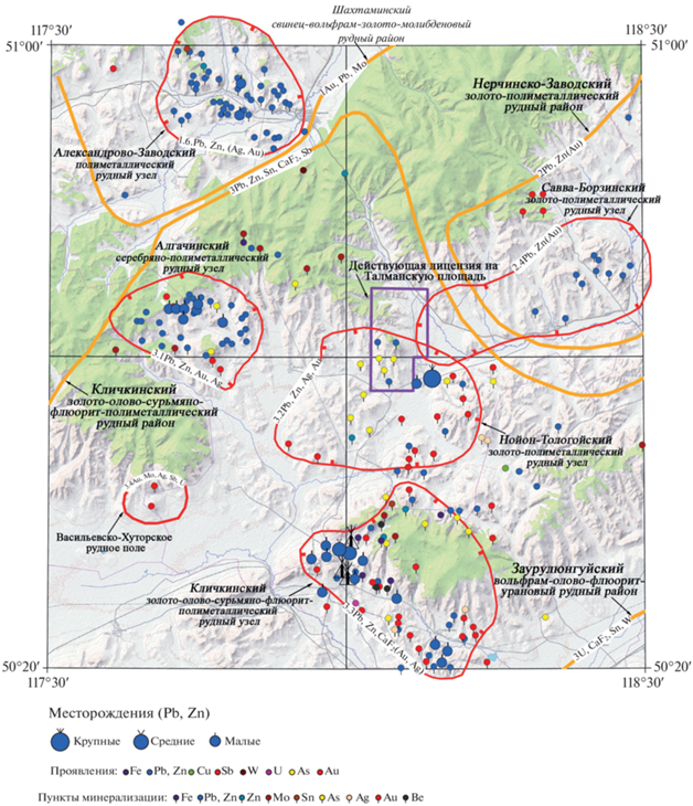
Исследуемая площадь Талман расположена в северной части Кличкинского золото-флюорит-полиметаллического рудного района (Нойон-Тологойский золото-полиметаллический рудный узел) в юго-восточном Забайкалье, Россия (рис. 1).
Рельеф низко-среднегорный, типичный для степей юго-восточного Забайкалья. Значения абсолютных высот изменяются от 750 до 1053 м. Относительные превышения водоразделов над днищами долин достигают 250–400 м. На северных склонах гор часто встречаются небольшие лесные массивы, образованные березой, ольхой, осиной, лиственницей с густым подлеском, южная экспозиция склона покрыта только травянистым покровом. В поймах ручьев редкие заросли кустарников. Обнаженность на площади в целом удовлетворительная. Климат района резко континентальный со значительными колебаниями суточных и сезонных температур (Асмодъяров, 2015; Калашников, 2019).
В металлогеническом отношении исследуемая площадь входит в состав Алгачинской подзоны Аргунской структурно-формационной зоны. В ее пределах распространены стратифицированные образования верхнего протерозоя, представленные флишоидной песчано-глинистой формацией венда, вулканогенно-осадочными отложениями юры и нижнего мела, а также четвертичными рыхлыми осадками русловых и озерных фаций. Интрузивный магматизм выразился в становлении плутонических, гипабиссального и субвулканических комплексов пермского и средне-позднеюрского возрастов различного состава.
Площадь Талман охватывает северо-западную часть площади наиболее перспективного на полиметаллы Нойон-Тологойского рудного узла. Роль ведущего минерагенетического фактора здесь играет Мулинская вулкано-тектоническая структура с выполняющими ее вулканитами мулинской серии и интрузивными образованиями. С ними связано золото-полиметаллическое оруденение, локализованное на месторождении Нойон-Тологой и месторождении Талман, а также на многочисленных рудопроявлениях и пунктах минерализации (Тарабарко, 2000).
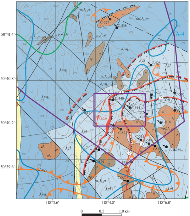
Главным критерием контроля и локализации золото-полиметаллического оруденения на площади Талман является наличие крупных неоднократно активизированных систем крутопадающих разломов и гетерогенность разреза стратифицированных пород с контрастными физико-механическими свойствами, способствующими заложению послойных срывов и зон трещиноватости, а также сосредоточению мелких рудных тел, выходящих на поверхность и локализованных в крутопадающих разломах (рис. 2).
Рудные тела сопровождаются широкими ореолами (первые десятки метров) гидротермально измененных пород. Гидротермальные изменения, как дорудные (хлорит-карбонатные, кварц-мусковитовые), синрудные (кварц-серицит-сульфидные), так и пострудные (кварц-гидрослюдистые и каолинитовые), телескопированы и оторваны от рудных тел до первых десятков, иногда сотен, метров по тектоническим нарушениям и в сочетании с другими критериями могут быть использованы в качестве прямого поискового признака.
Руды, выявленные в осадочно-вулканогенной толще, представлены кварц-карбонат-сульфидными жилами и в разной степени сульфидизированными кварц-карбонат-гидрослюдистыми метасоматитами. Рудовмещающими породами являются андезибазальты, базальты, плагиоандезиты, сиенит-порфиры, конгломераты средне-позднеюрского возраста (Лукин, 2020).
В составе руд выделяются главные и второстепенные рудные, породообразующие и акцессорные минералы. Главные рудные первичные (гипогенные) минералы: галенит, сфалерит арсенопирит, пирит, марказит; второстепенные рудные первичные минералы: буланжерит-джемсонит, пирротин, блеклые руды, халькопирит, бурнонит; акцессорные рудные первичные минералы: золото, серебро. Главные рудные гипергенные минералы: гидроокислы железа, марганца, плюмбоярозит, скородит, церуссит, ковеллин. Главные породообразующие первичные минералы: полевые шпаты, кварц, карбонаты, хлорит, гидрослюды, анкерит, каолинит, барит, апатит, рутил. Главные гипергенные минералы: кальцит, каолинит (Асмодъяров, 2015).
В пределах исследуемой территории в вулканогенно-осадочной толще (андезибазальтах, андезитах, конгломератах и песчаниках), в субвулканических сиенит-порфирах и плагиоандезитах, в базальтах дайкового комплекса широкое распространение получили средне- и низкотемпературные метасоматиты березитовой и аргиллизитовой формаций, слагающие наиболее интенсивные ореолы (более 30%) в сопряжениях разнонаправленных тектонически ослабленных зон разных порядков. На удалении от тектонических нарушений ореолы метасоматитов становятся неконтрастными и составляют не более 3–5% площади пород.
Обогащенные участки приурочены к тектонически проработанным контактам излившихся и осадочных пород. На поверхности минерализация представлена разнонаправленными окисленными прожилками мощностью от нитевидных до первых сантиметров. Ядра минерализованных зон представлены глинистыми лимонитизированными корами выветривания с выщелоченными сульфидами.
Подавляющая часть прогнозных ресурсов основных и попутных компонентов на площади Талман представлена первичными рудами. Окисленные руды имеют ограниченное распространение в пределах тектонических зон в условиях близповерхностного залегания рудных тел. Окисленные руды в большей степени характеризуются плюмбоярозит-ярозит-гидроокисным и, в меньшей степени – церуссит-миметезит-скородитовым типами, проявлены в приповерхностных условиях и являются остаточными. Количество их не превышает 8–10% общего объема рудной массы (Асмодъяров, 2015).
МАТЕРИАЛЫ И МЕТОДЫ
Космический аппарат дистанционного зондирования земли WorldView-2 был запущен на орбиту земли 08 октября 2009 г. Его оптический сенсор собирает данные в 9 спектральных каналах с динамическим диапазоном в 11 бит на пиксель (один канал широкого диапазона (панхроматический) и 8 каналов в VNIR диапазоне). Пространственное разрешение сцен WorldView-2 в панхроматическом режиме составляет 0.46 м/п, в мультиспектральном режиме – 1.84 м/п. Спектральные диапазоны каналов: панхроматический (0.45–0.80 μm); мультиспектральные: фиолетовый или coastal (0.40–0.45 μm), синий (0.45–0.51 μm), зеленый (0.51–0.58 μm), желтый (0.58–0.62 μm), красный (0.63–0.69 μm), крайний красный (0.70–0.74 μm), ближний инфракрасный-1 (0.77–0.9 μm), ближний инфракрасный-2 (0.86–1.04 μm).
В данной работе использовалась безоблачная и бесснежная сцена WorldView-2 уровня обработки 2А от 29 октября 2017 г., любезно предоставленная компанией PROXIMA (www.gisproxima.ru) для научных исследований.
В рамках предобработки набора изображений WorldView-2 на первом этапе проведена радиометрическая калибровка с целью конвертации цифровых значений (DN) пикселей изображения к зарегистрированной сенсором интенсивности излучения в верхних слоях атмосферы (Iwasaki, 2005). Затем данные излучения преобразованы в отражательную способность посредством применения алгоритма атмосферной коррекции FLAASH, основанного на аэрозольной модели атмосферы MODTRAN (Fraser, 1987). Для дифференциации растительного покрова и почв рассчитаны улучшенный индекс растительности WorldView (WV-VI) и нормализованный разностный водный индекс (NDWI).
Окислы и гидроокислы железа представляют собой важную группу минералов для дистанционного зондирования из-за схожих, ярко выраженных, хорошо идентифицируемых полос поглощения в видимой и ближней ИК-областях спектра. К этой группе минералов относятся: гематит, магнетит, гетит, ильменит, ярозит, а также лимонит. Высокое спектральное разрешение WorldView-2 в диапазонах VNIR позволяет отображать подробные спектральные характеристики поверхностных объектов: зоны концентрации минералов группы оксидов/гидроксидов, содержащих переходные ионы железа (Fe2+, Fe3+ и Fe3+/Fe2+). Характеристики поглощения, связанные с Fe3+/Fe2+, содержат набор от 0.40 до 1.2 μm, которые соответствуют каналам 2, 3, 4, 6 и 8 WorldView-2 VNIR (Bedini, Mars, 2018; 2019; Sun, 2017). Характеристики поглощения, связанные с Fe3+, обычно составляют 0.49, 0.70 и 0.87 μm, в то время как Fe2+ проявляет свойства поглощения при 0.51, 0.55 и 1.20 μm (Clark, 1999; Gaffey, 1986; Hunt, 1977, 1799).
В соответствии со спектральными особенностями поглощения группы минералов, содержащей оксиды и гидроксиды железа, для VNIR каналов WorldView-2 применена технология отношения спектральных каналов (минералогических индексов). Она широко используется и развивается многими исследователями для картирования гидротермально измененных пород, подчеркивая неочевидные человеческому глазу спектральные характеристики или особенности геологических объектов (Eldosouky, 2019; Pour, 2018; Rajendran, 2018). Технология основана на отношении, где в числителе использован канал с высокими значениями коэффициента отражения той или иной группы минералов или конкретного минерала, а в знаменателе – канал с низким значением коэффициента отражения (Crowley, 1989; Kalinowski, 2004). В работе спектральные каналы подбирались исходя из особенностей поглощения и отражения минералов группы оксидов и гидроксидов железа (гематит, магнетит, гетит, ярозит и т.д.), так как некоторые главные первичные рудные минералы в своем химическом составе имеют Fe (пирит, арсенопирит), а продукты их выветривания представлены окислами и гидроокислами железа со второй и третьей валентностью.
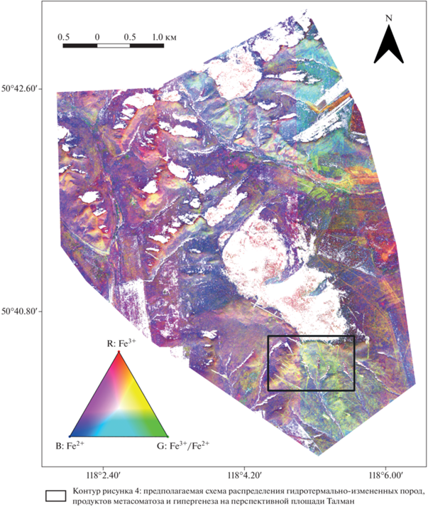
Для картирования Fe3+/Fe2+ использован минералогический индекс (b3*b4)/(b2*1000) (Segal, 1982); для картирования Fe3+ использован минералогический индекс (b4 + b2)/b3 (Pour, 2019); для картирования Fe2+ использован минералогический индекс (b6 + b8)/b7 (Pour, 2019). Далее подобран псевдоцветной RGB композит (рис. 3), который отображает классы геологических материалов, имеющих спектральные характеристики, связанные с оксидами/гидроксидами железа, где каналу R соответствует Fe3+, каналу G соответствует Fe3+/Fe2+, каналу B соответствует Fe2+. Тем самым, данная цветовая комбинация хорошо подчеркивает геоструктурные характеристики горных пород, связанные с гидротермальными изменениями. По мнению авторов, подобранный псевдо-цветной RGB композит является наиболее информативным для минералогического картирования исследуемой площади.
РЕЗУЛЬТАТЫ И ОБСУЖДЕНИЕ
По предложенной методике обработки данных WorldView-2 и подобранному псевдо-цветному композиту RGB (рис. 3), полученное изображение представлено в виде карты распределения минералов группы оксидов/гидроксидов, содержащих переходные ионы железа (Fe2+, Fe3+ и Fe3+/Fe2+), которая относит каждому пикселю минерал, условная вероятность появления которого в данной точке максимальна.
Учитывая одно из главных ограничений применения методов дистанционного зондирования в геологии, а именно глубину исследования поверхности, предлагаемая методика работы сводится к выявлению проявленности вторичных ореолов рассеяния на дневной поверхности, идентификации железа в почвах, в частности.
Наиболее благоприятные условия для образования вторичных наложенных ореолов рассеяния возникают при гипергенных изменениях полиметаллических месторождений. Вторичные наложенные ореолы рассеяния рудных месторождений способны проявляться при любой мощности рыхлых отложений (Миляев, 1988). В зоне гипергенеза железо представлено наибольшим количеством минералов (Зонн, 1982).
Главными источниками накопления железа в почвах являются первичные минералы почвообразующих пород. В них железо находится в закисных, окисных и гидроокисных соединениях. В результате выветривания и почвообразования железо из них высвобождается и переходит как в коллоидальные окисные, закисные и гидроокисные соединения, так и особенно во вторичные (глинистые) минералы. Из аморфного железа, появляющегося в результате разрушения первичных и вторичных минералов, образуются такие окисные и гидроокисные минералы, как гематит, гетит, маггемит и др. Гидроокись железа может образовывать с органическими кислотами подвижные формы комплексных соединений, способных перемещаться по профилю почвы. В почвах оксиды и гидроксиды железа различаются термодинамической стабильностью: ферригидрит, фероксигит, лепидокрокит и гетит. Ферригидрит является предшественником других, более устойчивых (гидр)оксидов железа, в первую очередь, гематита и гетита. К термодинамически нестабильным относят все гидроксиды, кроме гетита, свидетельствующие об идущем в настоящее время оксидогенезе железа. С течением времени фероксигит может спонтанно переходить в гетит, а ферригидрит – в гематит или гетит. Среди оксидов железа наиболее стабильный и распространенный минерал – гематит; магнетит и маггемит менее устойчивы (Зонн, 1982; Водяницкий, 2010).
В условиях средне-низкогорного рельефа и резко континентального климата образование вторичных остаточных ореолов рассеяния связано с процессами гипергенеза, что соответствует зоне активного влаго- и массообмеиа вещества (Миляев, 1988).
В соответствии с изложенным, поисковой значимостью для фиксации области гипергенеза будет выявление спектральной аномалии соотвествующее желто-зеленому цвету (треугольник RGB Fe3+/Fe2+, рис. 3). На псевдо-цветном RGB композите (рис. 3) представлены две спектральные аномалии с желто-зеленым оттенком, которые, возможно, соответсвуют гипергенным литохимическим аномалиям. С учетом физико-географических условий и масштабом выявленной аномалии наибольший интерес представляет спектральная аномалия в южной части представленного изображения, в пределах приводораздельного пологого южного склона г. Талман, свидетельствующая о наличии процессов окисления.
Практически весь псевдо-цветной RGB композит предствлен в красно-фиолетовых оттенках. С точки зрения химизма – это свободные Fe3+ и Fe2+. Fe2+ легко переходит в ионные растворы природных вод, способны перемещаться на далекие расстояния и не образуют комплексные ионы. Fe3+ образует труднорастворимые гидролизованные и сложные комплексные соединения.
Для заверки полученных результатов по обработанному космическиму снимку привлечены материалы из отчетов Росгеолфонда (Асмодъяров, 2015; Калашников, 2019; Назаров, 2017). К сожалению, с результатами геохимических работ (картографическими материалами) по площади Талман не удалось сравнить в связи с грифом “коммерческая тайна”, но тем не менее, получен удовлетворительный результат по сравнению со схематической геологической картой площади Талман. Выбранному участку по космическому снимку, с соответствующей спектральной аномалией, соответствует участок с выявленными минерализованными зонами, вскрытыми канавами и скважинами (рис. 4).
Рис. 4.
Предполагаемая схема распределения гидротермально-измененных пород, продуктов метасоматоза и гипергенеза на перспективной площади Талман.
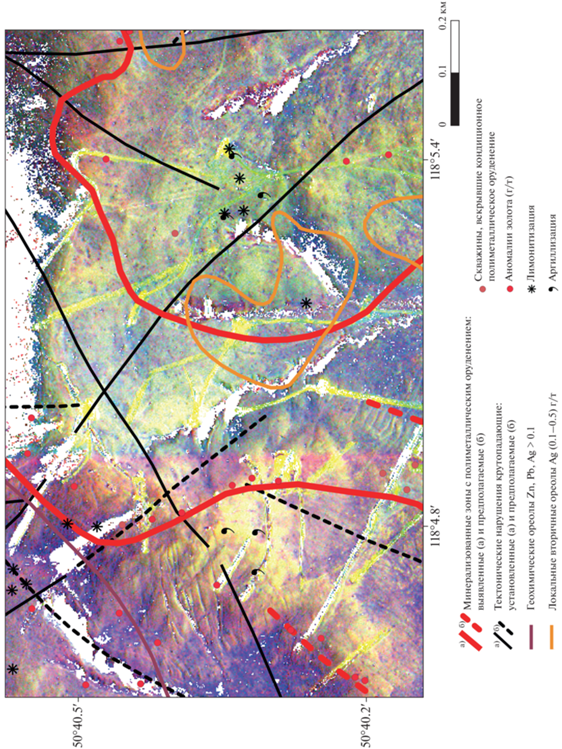
Согласно полученному псевдо-цветному RGB композиту и следуя логике распределения элемента-индикатора железа, перспективный участок является подковообразной структурой (рис. 4). Перспективность выбранного участка также обусловлена наличием разлома с второстепенными разрывами и оперяющими трещинами, которые образуют тектонически ослабленные зоны, пересекающие проявление, играющие важную рудоконтролирующую роль.
Выявленная спектральная аномалия пространственно не совсем согласуется с минерализованными зонами, так как пологопадающие минерализованные зоны располагаются на глубинах от 30 до 320 метров от дневной поверхности, но соответсвует предполагаемым ореолам рассеяния продуктов метасоматоза и гипергенеза.
Согласно фондовым материалам (Асмодъяров, 2015; Калашников, 2019; Назаров, 2017) на поверхности минерализация представлена глинистыми лимонитизированными корами выветривания с выщелоченными сульфидами, которая на обработанном снимке WorldView-2 представлена в цветовой гамме в желтых, зелено-желтых оттенках. Вскрытые канавы на обработанном космическом снимке WorldView-2 также представлены в желтых, зелено-желтых оттенках, так как вскрывают зону окисления руд. По полученному снимку видны проведенные ранее геохимические работы по вторичным ореолам рассеяния. Ориентировка профилей выбрана на основании анализа геолого-структурного положения наиболее перспективных участков простирания установленных и предполагаемых тектонических нарушений, что также доказывает предложенную методику по выявлению спектральных аномалий, соответсвующих гипергенным литохимическим аномалиям.
ЗАКЛЮЧЕНИЕ
Полученные результаты позволяют рассматривать спектральные аномалии зон, маркирующих околорудные изменения пород, в качестве индикатора для обоснования выбора участков детальных поисковых исследований в пределах перспективных площадей.
Использование предложенной методики для разбраковки существующей базы вторичных геохимических ореолов позволит:
– ранжировать по перспективности постановки геолого-разведочных работ;
– провести переоценку ряда рудопроявлений и геохимических аномалий, которые требуют дальнейшего изучения.
Примененный метод обработки данных WorldView-2 будет способствовать существенному снижению себестоимости работ при поисках скрытого золото-полиметаллического оруденения в условиях близповерхностного залегания рудных тел. Для России с ее обширными и труднодоступными территориями данные космической съемки высокого разрешения являются не только объективным фактором, отражающим текущее состояние и изменения природной среды, но и служат прекрасным информационным материалом для тематической обработки снимков с использованием современных методов и технологий.
Список литературы
Асмодъяров И.А., Брель А.И., Синявин В.И. и др. Поисково-ревизионные работы на золото-полиметаллическое оруденение в северной части Кличкинского золотополиметаллического рудного района (Забайкальский край) за 2012–2014 гг. Объект № 111-27(102-24). Отчет по Гос. контракту № К-01/12-6 от 20.03.12 г. Росгеолфонд № 515591. М., 2015.
Водяницкий Ю.Н. Соединения железа и их роль в охране почв. М.: ГНУ Почвенный институт им. В.В. Докучаева Россельхозакадемии, 2010. 155 с.
Зонн С.В. Железо в почвах (генетичнсекие и географические аспекты). М.: Наука, 1982. 209 с.
Калашников В.А., Лиханов В.Д., Четвериков М.Е. и др. Поисковые работы на золото-полиметаллическое оруденение в пределах Савва-Борзинского рудного узла (Забайкальский край). Росгеолфонд № 536243. М., 2019.
Лукин А.В. Паспорт № 205/5676, Объект учета Талман, 2020. 8 с.
Миляев С.А. Литохимические поиски полиметаллических месторождений. М.: Недра, 1988. 183 с.
Назаров А.А. Отчет о результатах работ по объекту № 630-17(111-23). Поисковые работы с оценкой песрпектив золото-полиметаллического оруденения основных руцдных районов и узлов Приаргунской структурно-формационной зоны (Забайкальский край). Росгеолфонд № 528679. М.: 2017.
Тарабарко А.Н. Закономерности размещения золото-полиметаллического оруденения Мулинской рудно-магматической системы // Геология, поиски и разведка рудных полезных ископаемых. 2000. № 24. С. 37–150.
Abdelsalam M., Stern R. Mapping gossans in arid regions with landsat TM and SIR-C images, the Beddaho Alteration Zone in northern Eritrea // J. Afr. Earth Sci. 2000. 30(4):903–916. https://doi.org/10.1016/S0899-5362(00)00059-2
Aydal D., Ardal E., Dumanlilar O. Application of the Crosta technique for alteration mapping of granitoidic rocks using ETM + data: case study from eastern Tauride belt (SE Turkey) // Int. J. Remote Sens. 2007. 28(17):3895–3913. https://doi.org/10.1080/01431160601105926
Bedini E. Application of WorldView-3 imagery and ASTER TIR data to map alteration minerals associated with the Rodalquilar gold deposits, southeast Spain // Adv. Space Res. 2019. 63. 3346–3357. https://doi.org/10.1016/j.asr.2019.01.047
Clark R.N. Spectroscopy of rock and minerals and principles of spectroscopy. In Remote Sensing for the Earth Sciences: Manual of Remote Sensing 3; Rencz A.N., Ed.; John Wiley Sons: New York, NY, USA, 1999. P. 3–58.
Crowley J.K., Brickey D.W., Rowan L.C. Airborne imaging spectrometer data of the Ruby Mountains, Montana: Mineral discrimination using relative absorption band-depth images // Remote Sens. Environ. 1989. 29. 121–134. https://doi.org/10.1016/0034-4257(89)90021-7
Eldosouky A.M., Sehsah H., Elkhateeb S.O., Pour A.B. Integrating aeromagnetic data and Landsat-8 imagery for detection of post-accretionary shear zones controlling hydrothermal alterations: The Allaqi-Heiani Suture zone, South Eastern Desert, Egypt // Adv. Space Res. 2020. 65. 1008–1024. https://doi.org/10.1016/j.asr.2019.10.030
Fraser S.J., Green A.A. A software defoliant for geological analysis of band ratios // Int. J. Remote Sens. 1987. 8. 525–532.
Gaffey S.J. Spectral reflectance of carbonate minerals in the visible and near-infrared (0.35–2.55 microns): Calcite, aragonite, and dolomite // Am. Mineral. 1986. 71. 151–162.
Hunt G.R. Spectral signatures of particulate minerals in the visible and near infrared // Geophysics. 1977. 42. 501–513. https://doi.org/10.1190/1.1440721
Hunt G.R., Ashley R.P. Spectra of altered rocks in the visible and near-infrared // Econ. Geol. 1979. 74. 1613–1629.
Inzana J., Kusky T., Higgs G., Tucker R. Supervised classifications of Landsat TM band ratio images and Landsat TM band ratio image with radar for geological interpretations of central Madagascar. J Afr Earth Sci. 2003. 37:59–72. https://doi.org/10.1016/S0899-5362(03)00071-X
Iwasaki A., Tonooka H. Validation of a crosstalk correction algorithm for ASTER/SWIR. IEEE Trans // Geosci. Remote Sens. 2005. 43. 2747–2751. https://doi.org/10.1109/TGRS.2005.855066
Kalinowski A., Oliver S. ASTER Mineral Index Processing Manual; Technical Report; Geoscience Australia: Canberra, Australia, 2004. Available online: http://www.ga.gov.au/image_cache/GA7833.pdf (accessed on 12 August 2018)
Kusky T.M., Ramadan T.M. Structural controls on Neoproterozoic mineralization in the South Eastern Desert, Egypt: an integrated field, Landsat TM, and SIR-C/X SAR approach // J Afr Earth Sci. 2002. 35:107–121. https://doi.org/10.1016/S0899-5362(02)00029-5
Mars J.C. Mineral and Lithologic Mapping Capability of WorldView 3 Data at Mountain Pass, California, Using True-and False-Color Composite Images, Band Ratios, and Logical Operator Algorithms // Econ. Geol. 2018. 113. 1587–1601. https://doi.org/10.5382/econgeo.2018.4604
Okada K., Segawa K., Hayashi I. Removal of the vegetation effect from LANDSAT TM and GER imaging spectroradiometer data. ISPRS J Photogramm Remote Sens. 1993. 48(6):16–27. https://doi.org/10.1016/0924-2716(93)90052-O
Podwysocki M.H., Mimms D.L., Salisbury J.W., Bender L.V., Jones O.D. Analysis of Landsat-4 TM data for lithologic and image mapping purpose, Proceedings of Landsat-4 Science Investigations Summary. Greenbelt, Maryland. 1984. 2:35–39.
Pour A.B., Hashim M., Hong J.K., Park Y. Lithological and alteration mineral mapping in poorly exposed lithologies using Landsat-8 and ASTER satellite data: North-eastern Graham Land, Antarctic Peninsula // Ore Geol. Rev. 2019. 108. 112–133. https://doi.org/10.1016/j.oregeorev.2017.07.018
Pour A.B., Park Y., Crispini L., Läufer A., Kuk Hong J., Park T.-Y.S., Zoheir B., Pradhan B., Muslim A.M., Hossain M.S. et al. Mapping Listvenite Occurrences in the Damage Zones of Northern Victoria Land, Antarctica Using ASTER Satellite Remote Sensing Data // Remote Sens. 2019. 11. 1408. https://doi.org/10.3390/rs11121408
Pour A.B., Park Y., Park T.S., Hong J.K., Hashim M., Woo J., Ayoobi I. Regional geology mapping using satellite-based remote sensing approach in Northern Victoria Land, Antarctica // Polar Sci. 2018. 16. 23–46. https://doi.org/10.1016/j.polar.2018.02.004
Pour A.B., Park T.S., Park Y., Hong J.K., Muslim A., Läufer A., Crispini L., Pradhan B., Zoheir B., Rahmani O., Hashim M., Hossain M.S. Landsat-8, Advanced Spaceborne Thermal Emission and Reflection Radiometer, and WorldView-3 Multispectral Satellite Imagery for Prospecting Copper-Gold Mineralization in the Northeastern Inglefield Mobile Belt (IMB), Northwest Greenland // Remote Sens. 2019. 11. 2430. https://doi.org/10.3390/rs11202430
Rajendran S., Sobhi N. ASTER capability in mapping of mineral resources of arid region: A review on mapping of mineral resources of the Sultanate of Oman // Ore Geol. Rev. 2018. 88. 317–335. https://doi.org/10.1016/j.oregeorev.2018.04.014
Rajesh H.M. Mapping Proterozoic unconformity-related uranium deposits in the Rockole area, Northern Territory, Australia using Landsat ETM+ // Ore Geol Rev. 2008. 33:382–396. https://doi.org/10.1016/j.oregeorev.2007.02.003
Ramadan T.M., Abdel Fattah M.F. Characterization of gold mineralization in Garin Hawal area, Kebbi State, NW Nigeria, using remote sensing // Egypt J Remote Sens Space Sci. 2010. 13:153–163. https://doi.org/10.1016/j.ejrs.2009.08.001
Rowan L.C., Goetz A.F.H., Ashley R.P. Discrimination of hydrothermally altered and unaltered rocks in visible and near infrared multispectral images // Geophysics. 1977. 42(3):522–535. https://doi.org/10.1190/1.1440723
Sabins F.F. Remote Sensing Principles and Interpretation. 3. New York, USA: Freeman & Co, 1996.
Sabins F.F. Remote sensing strategies for mineral exploration. In: Rencz AE, editor / Remote Sensing for the Earth Sciences. New York: John Wiley & Sons, Inc. 1997. P. 375–447.
Segal D. Theoretical Basis for Differentiation of Ferric-Iron Bearing Minerals, Using Landsat MSS Data / Proceedings of Symposium for Remote Sensing of Environment, 2nd Thematic Conference on Remote Sensing for Exploratory Geology, Fort Worth, TX (1982). 949–951.
Sun Y., Tian S., Di B. Extracting mineral alteration information using Worldview-3 data // Geosci. Front. 201. 8. 1051–1062. https://doi.org/10.1016/j.gsf.2016.10.008
Salehi T., Tangestani M. Large-scale mapping of iron oxide and hydroxide minerals of Zefreh porphyry copper deposit, using Worldview-3 VNIR data in the Northeastern Isfahan, Iran // International Journal of Applied Earth Observation and Geoinformation. December 2018. V. 73. P. 156–169.
Asmod’yarov I.A., Brel’ A.I., Sinyavin V.I. et al. Poiskovo-revizionnye raboty na zoloto-polimetallicheskoe orudenenie v severnoj chasti Klichkinskogo zolotopolimetallicheskogo rudnogo rajona (Zabajkal’skij kraj) za 2012-2014 gg. Ob’ekt № 111-27 (102-24). Otchet po Gos.kontraktu № K-01/12-6 ot 20.03.12 g. Rosgeolfond № 515591. M., 2015.
Vodyanickij YU.N. Soedineniya zheleza i ih rol’ v ohrane pochv. M.: GNU Pochvennyj institut im. V.V. Dokuchaeva Rossel’hozakademii, 2010. 155 s.
Zonn S.V. ZHelezo v pochvah (genetichnsekie i geograficheskie aspekty). M.: Nauka, 1982. 209 s. Kalashnikov V.A., Lihanov V.D., Chetverikov M.E. et al. Poiskovye raboty na zoloto-polimetallicheskoe orudenenie v predelah Savva-Borzinskogo rudnogo uzla (Zabajkal’skij kraj). Rosgeolfond № 536243. M., 2019. Lukin A.V. Pasport № 205/5676, Ob’ekt ucheta Talman, 2020. 8 p. Milyaev S.A. Litohimicheskie poiski polimetallicheskih mestorozhdenij. M.: Nedra, 1988. 183 p. Nazarov A.A. Otchet o rezul’tatah rabot po ob’ektu № 630-17(111-23). Poiskovye raboty s ocenkoj pesrpektiv zoloto-polimetallicheskogo orudeneniya osnovnyh rucdnyh rajonov i uzlov Priargunskoj strukturno-formacionnoj zony (Zabajkal’skij kraj). Rosgeolfond № 528679. M., 2017.
Tarabarko A.N. Zakonomernosti razmeshcheniya zoloto-polimetallicheskogo orudeneniya Mulinskoj rudno-magmaticheskoj sistemy // Geologiya, poiski i razvedka rudnyh poleznyh iskopaemyh. 2000. № 24. P. 37–150.
Abdelsalam M., Stern R. Mapping gossans in arid regions with landsat TM and SIR-C images, the Beddaho Alteration Zone in northern Eritrea // J Afr Earth Sci. 2000; 30(4):903–916. https://doi.org/10.1016/S0899-5362(00)00059-2
Aydal D., Ardal E., Dumanlilar O. Application of the Crosta technique for alteration mapping of granitoidic rocks using ETM + data: case study from eastern Tauride belt (SE Turkey) // Int J Remote Sens. 2007; 28(17):3895–3913. https://doi.org/10.1080/01431160601105926
Bedini E. Application of WorldView-3 imagery and ASTER TIR data to map alteration minerals associated with the Rodalquilar gold deposits, southeast Spain // Adv. Space Res. 2019. 63. 3346–3357. https://doi.org/10.1016/j.asr.2019.01.047
Clark R.N. Spectroscopy of rock and minerals and principles of spectroscopy. In Remote Sensing for the Earth Sciences: Manual of Remote Sensing 3; Rencz, A.N., Ed.; John Wiley Sons: New York, NY, USA, 1999; P. 3–58.
Crowley J.K., Brickey D.W., Rowan L.C. Airborne imaging spectrometer data of the Ruby Mountains, Montana: Mineral discrimination using relative absorption band-depth images // Remote Sens. Environ. 1989. 29. 121–134. https://doi.org/10.1016/0034-4257(89)90021-7
Eldosouky A.M., Sehsah H., Elkhateeb S.O., Pour A.B. Integrating aeromagnetic data and Landsat-8 imagery for detection of post-accretionary shear zones controlling hydrothermal alterations: The Allaqi-Heiani Suture zone, South Eastern Desert, Egypt // Adv. Space Res. 2020. 65. 1008–1024. https://doi.org/10.1016/j.asr.2019.10.030
Fraser S.J., Green A.A. A software defoliant for geological analysis of band ratios // Int. J. Remote Sens. 1987. 8. 525–532.
Gaffey S.J. Spectral reflectance of carbonate minerals in the visible and near-infrared (0.35–2.55 microns): Calcite, aragonite, and dolomite // Am. Mineral. 1986. 71. 151–162.
Hunt G.R. Spectral signatures of particulate minerals in the visible and near infrared // Geophysics. 1977. 42. 501–513. https://doi.org/10.1190/1.1440721
Hunt G.R., Ashley R.P. Spectra of altered rocks in the visible and near-infrared // Econ. Geol. 1979. 74. 1613–1629.
Inzana J., Kusky T., Higgs G., Tucker R. Supervised classifications of Landsat TM band ratio images and Landsat TM band ratio image with radar for geological interpretations of central Madagascar. J Afr Earth Sci. 2003. 37:59–72. https://doi.org/10.1016/S0899-5362(03)00071-X
Iwasaki A., Tonooka H. Validation of a crosstalk correction algorithm for ASTER/SWIR. IEEE Trans // Geosci. Remote Sens. 2005. 43. 2747–2751. https://doi.org/10.1109/TGRS.2005.855066
Kalinowski A., Oliver S. ASTER Mineral Index Processing Manual; Technical Report; Geoscience Australia: Canberra, Australia, 2004. Available online: http://www.ga.gov.au/image_cache/GA7833.pdf (accessed on 12 August 2018).
Kusky T.M., Ramadan T.M. Structural controls on Neoproterozoic mineralization in the South Eastern Desert, Egypt: an integrated field, Landsat TM, and SIR-C/X SAR approach // J Afr Earth Sci. 2002. 35:107–121. https://doi.org/10.1016/S0899-5362(02)00029-5
Mars J.C. Mineral and Lithologic Mapping Capability of WorldView 3 Data at Mountain Pass, California, Using True-and False-Color Composite Images, Band Ratios, and Logical Operator Algorithms // Econ. Geol. 2018. 113. 1587–1601. https://doi.org/10.5382/econgeo.2018.4604
Okada K., Segawa K., Hayashi I. Removal of the vegetation effect from LANDSAT TM and GER imaging spectroradiometer data. ISPRS J Photogramm Remote Sens. 1993. 48(6):16–27. https://doi.org/10.1016/0924-2716(93)90052-O
Podwysocki M.H., Mimms D.L., Salisbury J.W., Bender L.V., Jones O.D. Analysis of Landsat-4 TM data for lithologic and image mapping purpose, Proceedings of Landsat-4 Science Investigations Summary. Greenbelt, Maryland. 1984. 2:35–39.
Pour A.B., Hashim M., Hong J.K., Park Y. Lithological and alteration mineral mapping in poorly exposed lithologies using Landsat-8 and ASTER satellite data: North-eastern Graham Land, Antarctic Peninsula // Ore Geol. Rev. 2019. 108. 112–133. https://doi.org/10.1016/j.oregeorev.2017.07.018
Pour A.B., Park Y., Crispini L., Läufer A., Kuk Hong J., Park T.-Y.S., Zoheir B., Pradhan B., Muslim A.M., Hossain M.S. et al. Mapping Listvenite Occurrences in the Damage Zones of Northern Victoria Land, Antarctica Using ASTER Satellite Remote Sensing Data // Remote Sens. 2019. 11. 1408. https://doi.org/10.3390/rs11121408
Pour A.B., Park Y., Park T.S., Hong J.K., Hashim M., Woo J., Ayoobi I. Regional geology mapping using satellite-based remote sensing approach in Northern Victoria Land, Antarctica // Polar Sci. 2018. 16. 23–46. https://doi.org/10.1016/j.polar.2018.02.004
Pour A.B., Park T.S., Park Y., Hong J.K., Muslim A., Läufer A., Crispini L., Pradhan B., Zoheir B., Rahmani O., Hashim M., Hossain M.S. Landsat-8, Advanced Spaceborne Thermal Emission and Reflection Radiometer, and WorldView-3 Multispectral Satellite Imagery for Prospecting Copper-Gold Mineralization in the Northeastern Inglefield Mobile Belt (IMB), Northwest Greenland // Remote Sens. 2019. 11. 2430. https://doi.org/10.3390/rs11202430
Rajendran S., Sobhi N. ASTER capability in mapping of mineral resources of arid region: A review on mapping of mineral resources of the Sultanate of Oman // Ore Geol. Rev. 2018. 88. 317–335. https://doi.org/10.1016/j.oregeorev.2018.04.014
Rajesh H.M. Mapping Proterozoic unconformity-related uranium deposits in the Rockole area, Northern Territory, Australia using Landsat ETM+ // Ore Geol Rev. 2008. 33:382–396. https://doi.org/10.1016/j.oregeorev.2007.02.003
Ramadan T.M., Abdel Fattah M.F. Characterization of gold mineralization in Garin Hawal area, Kebbi State, NW Nigeria, using remote sensing // Egypt J Remote Sens Space Sci. 2010. 13:153–163. https://doi.org/10.1016/j.ejrs.2009.08.001
Rowan L.C., Goetz A.F.H., Ashley R.P. Discrimination of hydrothermally altered and unaltered rocks in visible and near infrared multispectral images // Geophysics. 1977. 42(3):522–535. https://doi.org/10.1190/1.1440723
Sabins F.F. Remote Sensing Principles and Interpretation. 3. New York, USA: Freeman & Co; 1996.
Sabins F.F. Remote sensing strategies for mineral exploration. In: Rencz AE, editor / Remote Sensing for the Earth Sciences. New York: John Wiley & Sons, Inc; 1997. P. 375–447.
Segal D. Theoretical Basis for Differentiation of Ferric-Iron Bearing Minerals, Using Landsat MSS Data / Proceedings of Symposium for Remote Sensing of Environment, 2nd Thematic Conference on Remote Sensing for Exploratory Geology, Fort Worth, TX (1982): 949–951.
Sun Y., Tian S., Di B. Extracting mineral alteration information using Worldview-3 data // Geosci. Front. 2017. 8. 1051–1062. https://doi.org/10.1016/j.gsf.2016.10.008
Salehi T., Tangestani M. Large-scale mapping of iron oxide and hydroxide minerals of Zefreh porphyry copper deposit, using Worldview-3 VNIR data in the Northeastern Isfahan, Iran // International Journal of Applied Earth Observation and Geoinformation. December 2018. V. 73 P. 156–169.
Дополнительные материалы отсутствуют.
Инструменты
Исследование Земли из Космоса